Categories
Planning

Off the Grid at TRB

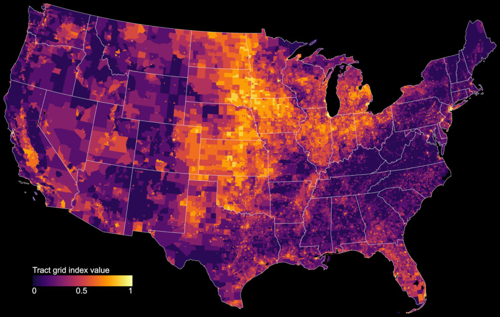
I am presenting my ongoing research into the recent evolution of American street network planning and design at the annual meeting of the Transportation Research Board in Washington DC on January 13. This presentation asks the question: how has street network design changed over time, especially in recent years? I analyze the street networks of every US census tract and estimate each’s vintage.

Street network designs grew more disconnected, coarse-grained, and circuitous over the 20th century… but the 21st century has witnessed a promising rebound back toward more traditional, dense, and interconnected grids. Higher griddedness is associated with less car ownership, even when controlling for related socioeconomic, topographical, and other urban factors.

Update: the paper has been published in JAPA.

Categories
Urban

Big Data in Urban Morphology

My new article “Spatial Information and the Legibility of Urban Form: Big Data in Urban Morphology” has been published in the International Journal of Information Management (download free PDF). It builds on recent work by Crooks et al, presenting workflows to integrate data-driven and narrative approaches to urban morphology in today’s era of ubiquitous urban big data. It situates this theoretically in the visual culture of planning to present a visualization-mediated interpretative process of data-driven urban morphology, focusing on transportation infrastructure via OSMnx.

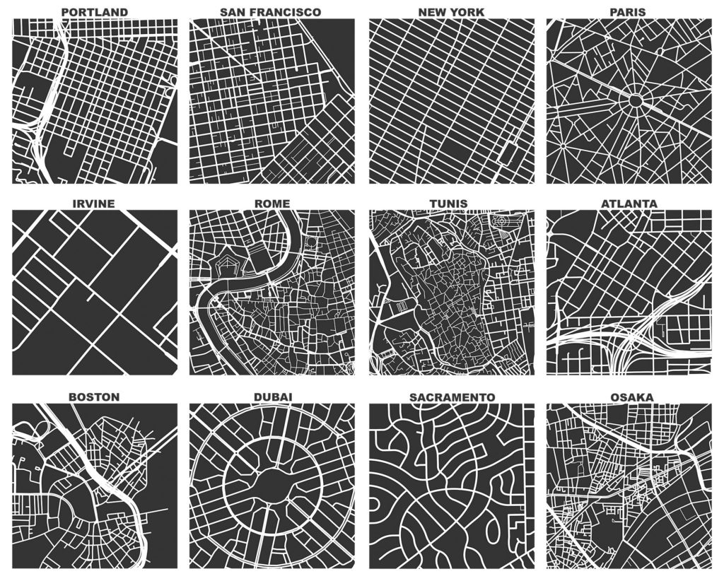
OSMnx: Figure-ground diagrams of one square mile of each street network, from OpenStreetMap, made in Python with matplotlib, geopandas, and NetworkX

Categories
Urban

Urban Street Network Orientation

My new article, Urban Spatial Order: Street Network Orientation, Configuration, and Entropy, has just been published in one of my favorite journals: Applied Network Science (download free PDF). This study explores the spatial signatures of urban evolution and central planning. It examines street network orientation, connectivity, granularity, and entropy in 100 cities around the world using OpenStreetMap data and OSMnx for modeling and visualization:

City street network grid orientations, order, disorder, entropy, rose plot, polar histogram made with Python, OSMnx, OpenStreetMap, matplotlib.

So, who’s got a grid and who doesn’t? Each of the cities above is represented by a polar histogram (aka rose diagram) depicting how its streets orient. Each bar’s direction represents the compass bearings of the streets (in that histogram bin) and its length represents the relative frequency of streets with those bearings. The cities above are in alphabetical order. Here they are again, re-sorted from most-ordered/gridded city (Chicago) to most-disordered (Charlotte):

Categories
Data

US Street Network Models and Measures

My new article, “Street Network Models and Measures for Every U.S. City, County, Urbanized Area, Census Tract, and Zillow-Defined Neighborhood” has been published in Urban Science. This paper reports results from a broader project that collected raw street network data from OpenStreetMap using the Python-based OSMnx software for every U.S. city and town, county, urbanized area, census tract, and Zillow-defined neighborhood boundary. It constructed nonplanar directed multigraphs for each and analyzed their structural and morphological characteristics.

The resulting public data repository contains over 110,000 processed, cleaned street network graphs (which in turn comprise over 55 million nodes and over 137 million edges) at various scales—comprehensively covering the entire U.S.—archived as reusable open-source GraphML files, node/edge lists, and ESRI shapefiles that can be immediately loaded and analyzed in standard tools such as ArcGIS, QGIS, NetworkX, graph-tool, igraph, or Gephi.

Categories
Data

Street Network Analysis in a Docker Container

Containerization is the way of the future present. I’ve heard feedback from some folks over the past few months who would like to play around with OSMnx for street network analysis, transport modeling, and urban design—but can’t because they can’t install Python and its data science stack on their computers. Furthermore, it would be nice to have a consistent reference environment to deploy on AWS or elsewhere in the cloud.

So, I’ve created a docker image containing OSMnx, Jupyter, and the rest of the Python geospatial data science stack, available on docker hub alongside additional usage instructions. If you’re starting from scratch, you can get started in four simple steps:

Categories
Planning

New Chapter: Street Network Morphology

My chapter The Morphology and Circuity of Walkable and Drivable Street Networks is now in-press for publication in the forthcoming book The Mathematics of Urban Morphology (download free PDF). The book integrates recent theoretical and empirical work from urban planning, geography, sociology, architecture, economics, and mathematics around the theme of how we model and understand the urban form’s physical patterns and shaping processes. Fellow authors in this volume include Michael Batty, Diane Davis, Keith Clarke, Bin Jiang, Kay Axhausen, Carlo Ratti, and Stephen Marshall. The book itself can be purchased here.

Categories
Planning

New Article: Planar Models of Street Networks

My article, “Planarity and Street Network Representation in Urban Form Analysis,” was recently published in Environment and Planning B: Urban Analytics and City Science. Models of street networks underlie research in urban travel behavior, accessibility, design patterns, and morphology. These models are commonly defined as planar, meaning they can be represented in two dimensions without any underpasses or overpasses. However, real-world urban street networks exist in three-dimensional space and frequently feature grade separation such as bridges and tunnels: planar simplifications can be useful but they also impact the results of real-world street network analysis. This study measures the nonplanarity of drivable and walkable street networks in the centers of 50 cities worldwide, then examines the variation of nonplanarity across a single city. While some street networks are approximately planar, I empirically quantify how planar models can inconsistently but drastically misrepresent intersection density, street lengths, routing, and connectivity.

Categories
Urban

New Article: Complexity in Urban Form and Design

My article, Measuring the Complexity of Urban Form and Design, is now in-press for publication at Urban Design International (download free PDF). Cities are complex systems composed of many human agents interacting in physical urban space. This paper develops a typology of measures and indicators for assessing the physical complexity of the built environment at the scale of urban design. It extends quantitative measures from city planning, network science, ecosystems studies, fractal geometry, statistical physics, and information theory to the analysis of urban form and qualitative human experience.

The Mandelbrot set, a mathematical fractal. Venice's fractal urban form and fabric. The Eiffel Tower's fractal architecture in Paris.

Categories
Planning

New Article: Urban Street Networks in EP-B

My article, “A Multi-Scale Analysis of 27,000 Urban Street Networks: Every US City, Town, Urbanized Area, and Zillow Neighborhood,” was recently published in Environment and Planning B: Urban Analytics and City Science. This study uses OSMnx to download and analyze 27,000 street networks from OpenStreetMap at metropolitan, municipal, and neighborhood scales – namely, every US city and town, census urbanized area, and Zillow-defined neighborhood. It illustrates the use of OSMnx and OpenStreetMap to consistently conduct street network analysis with extremely large sample sizes, with clearly defined network definitions and extents for reproducibility, and using nonplanar, directed graphs.

These 27,000 street networks as well as their measures have been shared in a free public repository at the Harvard Dataverse for anyone to re-purpose. This study’s empirical findings emphasize measures relevant to graph theory, transportation, urban design, and morphology, such as structure, connectedness, density, centrality, and resilience. It uses graph Maximum Betweenness Centrality and Average Node Connectivity to examine how “resilient” a street network is, in terms of how reliant it is on important nodes and how easy it is to disconnect it.

Categories
Planning

City Street Orientations around the World

City street network grid orientations, order, disorder, entropy, rose plot, polar histogram made with Python, OSMnx, OpenStreetMap, matplotlib.This post is adapted from this research paper that you can read/cite for more info. It analyzes and visualizes 100 cities around the world.

By popular request, this is a quick follow-up to this post comparing the orientation of streets in 25 US cities using Python and OSMnx. Here are 25 more cities around the world:

City street network grid orientations, rose plot, polar histogram made with Python, OSMnx, OpenStreetMap, matplotlib. Bangkok, Barcelona, Beijing, Budapest, Cairo, Delhi, Dubai, Glasgow, Hong Kong, Lagos, London, Madrid, Melbourne, Mexico City, Moscow, Mumbai, Munich, Paris, Rio de Janeiro, Rome, Seoul, Sydney, Tehran, Toronto, Warsaw, Tokyo, Berlin, Venice