What's New With OSMnx, Part 2
This is a follow-up to last month’s post discussing the many new features, improvements, and optimizations made to OSMnx this summer. As this major improvement project now draws to a close, I will summarize what’s new(er) here. Long story short: there are a bunch of new features and everything in the package has been streamlined and optimized to be easier to use, faster, and more memory efficient.
First off, if you haven’t already, read the previous post about new features including topological intersection consolidation, automatic max speed imputation and travel time calculation, generalized points-of-interest queries, querying OSM by date, and API streamlining. This post covers new changes since then, including improved visualization and plotting, improved graph simplification, the new geocoder module, and other miscellaneous improvements.
Improved visualization
The plot module and all plotting functions have been streamlined for easier usage, optimized for faster performance with a smaller memory footprint, and enhanced with new features. The usage examples and particularly this notebook demonstrate new visualization functionality.
Plotting default arguments have been improved for easier attractive plots. Some function parameters were deprecated in a previous release and removed in the current release to streamline usability. The plot_shape function was also deprecated and eventually removed, as its functionality can be recreated in a single line by just calling the gdf.plot function.
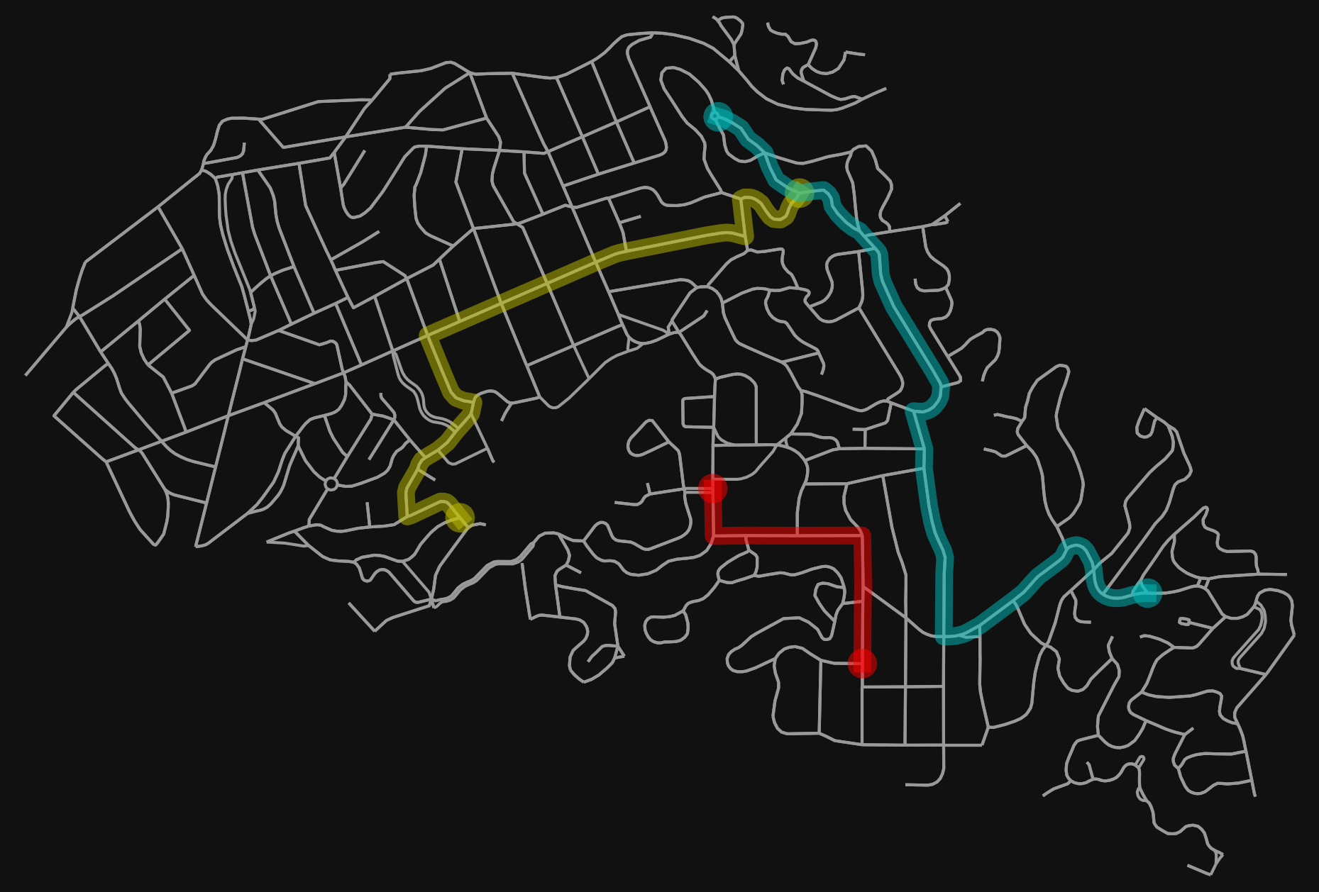
Additionally, the plot_graph_route function now accepts kwargs to pass along to plot_graph, and the plot_graph_routes function now accepts kwargs to pass along to plot_graph_route, simplifying all of their usage. The plot_graph_routes function also can now take a list of colors to visualize each route separately.
# get a graph
G = ox.graph_from_place('Piedmont, CA, USA', network_type='drive')

# impute missing edge speeds and calculate free-flow travel times
G = ox.add_edge_speeds(G)
G = ox.add_edge_travel_times(G)

# calculate 3 shortest paths minimizing travel time
wt = 'travel_time'
route1 = nx.shortest_path(G, list(G)[10], list(G)[-10], weight=wt)
route2 = nx.shortest_path(G, list(G)[0], list(G)[-1], weight=wt)
route3 = nx.shortest_path(G, list(G)[-100], list(G)[100], weight=wt)

# plot the 3 routes
routes = [route1, route2, route3]
colors = ['r', 'y', 'c']
fig, ax = ox.plot_graph_routes(G, routes, route_colors=colors, node_size=0)
Color handling in the plot module has also been substantially improved. For example, the get_edge_colors_by_attr and get_node_colors_by_attr functions now can either:
- bin attribute values into equal-sized quantiles
- bin attribute values into equal-spaced bins
- linearly map a matplotlib colormap to each node/edge based on its attribute value
New geocoder module
The new geocoder module consolidates all of OSMnx’s geocoding functionality in one place. This includes the geocode function. It also replaces the gdf_from_place and gdf_from_places functions with a new flexible geocode_to_gdf function. The old gdf_from_place/s functions and their boundaries module have been deprecated with a user warning and will be removed in a future release.
Improved graph simplification
OSMnx now simplifies graphs better, faster, and with a smaller memory footprint. Previously, it used a recursive topological simplification algorithm that could fail on extremely long rural roads by exceeding the system’s maximum recursion depth. Now, it can simplify indefinitely long road segments. It also by default now removes isolated self-contained rings that have no endpoints.
Other improvements
In addition to the speed and memory optimizations described above, additional efficiency improvements have been made to the project_graph, graph_to_gdfs, and graph_from_gdfs functions in particular, all of which are faster and leaner now. These functions are used internally in many parts of the codebase, which amplifies these speed/memory improvements.
Additionally, OSMnx’s elevation module previously could only use the Google Maps Elevation API. Now it allows multiple elevation API providers, including AirMap. Finally, a previous release deprecated the timeout, memory, custom_settings, and max_query_area_size parameters in all the graph_from_whatever functions, making everything a bit less cluttered. These parameters are now configurable instead via the config function and the settings module.
Looking ahead
An upcoming release will include the following new features:
- a new k_shortest_paths function to solve k shortest paths from an origin to a destination
- a new shortest_path convenience function
- a new get_digraph function to correctly convert MultiDiGraph to DiGraph
Finally, looking further ahead, I intend to eventually merge the pois and footprints modules, which have become approximately redundant. For more info on the many OSMnx improvements and changes this summer, check out the documentation, the usage examples, or the OSMnx features round-up. In particular, API changes are discussed in this issue.
Update: this summer project has now concluded and been released. More info.