What's New with OSMnx, Part 1
There have been some major changes to OSMnx in the past couple months. I’ll review them briefly here, demonstrate some usage examples, then reflect on a couple upcoming improvements on the horizon. First, what’s new:
- new consolidate_intersections function with topological option
- new speed module to impute missing street speeds and calculate travel times for all edges
- generalized POIs module to query with a flexible tags dict
- you can now query OSM by date
- you can now save graph as a geopackage file
- clean up and streamline the OSMnx API
A few other changes clean up argument usage for consistency (e.g., all saving functions now have a consistent filepath parameter and all “dist” or “distance” parameters have been replaced with a consistent dist parameter). Modules have been refactored as well. You can see a list of changes in the change log and this issue.
Topological Intersection Consolidation
Many real-world street networks feature complex intersections and traffic circles, resulting in a cluster of graph nodes where there is really just one true intersection as we would think of it in transportation or urban design. Similarly, divided roads are often represented by separate centerline edges: the intersection of two divided roads thus creates 4 nodes, representing where each edge intersects a perpendicular edge, but these 4 nodes represent a single intersection in the real world. Traffic circles similarly create a cluster of nodes where each street’s edge intersects the roundabout.
OSMnx can consolidate nearby intersections and now optionally rebuild the graph’s topology to reconnect edges to the newly consolidated nodes.
import osmnx as ox
G = ox.project_graph(ox.graph_from_place('San Francisco, California, USA', network_type='drive'))
G2 = ox.consolidate_intersections(G, tolerance=10, rebuild_graph=True, dead_ends=True)

If we plot a portion of this network (above), notice how the traffic circles’ many (red) nodes are merged into a new single centroid node (black), with edge geometries extended to connect to it. Similar consolidation occurs at the intersection of the divided road in the upper- right.
Running consolidate_intersections with rebuild_graph=True may yield somewhat
(but not very) different intersection counts/densities compared to
rebuild_graph=False. The difference lies in that the latter just merges
buffered node points that overlap, whereas the former checks the topology of the
overlapping node buffers before merging them. This prevents topologically remote
but spatially proximate nodes from being merged. For example:
- A street intersection may lie directly below a freeway overpass’s intersection with an on-ramp. We would not want to merge these together and connnect their edges: they are distinct junctions in the system of roads.
- In a residential neighborhood, a bollarded street may create a dead-end immediately next to an intersection or traffic circle. We would not want to merge this dead-end with the intersection and connect their edges.
These examples illustrate (two-dimensional) geometric proximity but topological remoteness.
Accordingly in certain situations we may expect higher intersection counts when
using rebuild_graph=True because it is more cautious with merging in these
cases. The trade-off is that it has higher time complexity than
rebuild_graph=False. For best results, the tolerance argument should be
adjusted to approximately match street design standards in the specific street
network, and you should always use a projected graph to work in meaningful and
consistent units like meters. You can also specify if you do not want dead- ends
returned in the list of cleaned intersections.
Speed and Travel Time
The new add_edge_speeds function adds edge speeds (km/hour) to a graph as new
speed_kph edge attributes. It imputes free-flow travel speeds for all edges
based on mean maxspeed value of edges per highway type. This mean- imputation
can obviously be imprecise, so the caller can override it by passing in a
hwy_speeds dict and/or a fallback argument to correspond to local speed
limit standards.
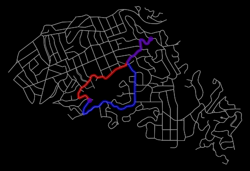
This allows you to easily calculate shortest-path routes that minimize travel time (blue) rather than distance (red):
See the documentation for details and this notebook for a usage example.
Generalized POIs Queries
Update: as of v0.16.0, the pois module and functionality has been incorporated into and superseded by the new geometries module:more info.
The pois (points of interest) module now takes a flexible tags dict in all of
its OpenStreetMap queries, allowing you to query for any spatial entities. You
are no longer limited to just amenities only. For example:
# get everything tagged amenity,
# and everything with landuse = retail or commercial,
# and everything with highway = bus_stop
tags = {'amenity' : True,
    'landuse' : ['retail', 'commercial'],
    'highway' : 'bus_stop'}
gdf = ox.pois_from_place('Piedmont, CA, USA', tags)
gdf.shape
See documentation for details or this notebook for a usage example.
Query OSM by Date
You can now query OpenStreetMap data as of a certain date, using the
custom_settings parameter. For example, to query the database as of 28 October
2019 at 7:20 PM, you can use:
cs = '[out:json][timeout:180][date:"2019-10-28T19:20:00Z"]'
gdf = ox.pois_from_address(some_address, tags={"amenity": "school"}, custom_settings=cs)
This allows you to explore historical snapshots of the data set.
Save graph as GeoPackage
OSMnx can save your graph to disk as an ESRI shapefile, GraphML file, .osm formatted XML file, and now GeoPackage. Shapefiles have a lot of limitations, so GeoPackage saving offers a superior modern file format for subsequent GIS work.
Streamlined API
Over time, the OSMnx API and top-level namespace had become cluttered and increasingly unintuitive. Many of its modules had similarly grown unwieldy and its functional organization needed a rethink. The newly redesigned API:
- only imports the primary user functions from the various modules into the
ox.namespace (comprising the vast majority of end-user use cases) - allows all other less-common user functions to be accessed via
ox.module_name.function_name() - makes all internal functions private/hidden
This makes package usage, documentation, code hinting, and code completion more simple, streamlined, and straightforward - but note that it is not 100% backwards compatible. For details, see the change log, the documentation, and the updated usage examples. In particular, these changes are discussed in this issue.
Looking ahead
The next release will remove three deprecated functions: graph_from_file
(replaced in v0.13.0 by graph_from_xml), clean_intersections (replaced in
v0.13.0 by consolidate_intersections), and gdfs_to_graph (replaced in
v0.13.0 by graph_from_gdfs). It will also remove the old clunky
infrastructure parameter in favor of a streamlined, flexible custom_filter
parameter for all the ox.graph_from_whatever functions.
Subsequent releases this summer will continue this project and improve plotting and color handling, geocoding, settings/config, graph simplification, and speed and memory efficiency throughout. Looking further ahead, I intend to eventually merge the pois and footprints modules, which have become approximately redundant.
For more info, check out the documentation, the usage examples, or the OSMnx features round-up.