Categories
Urban

Housing Tech and Tilted Platforms

I have a new article out now in a special issue on platform urbanism, co-authored with Max Besbris, David Wachsmuth, and Jake Wegmann, titled Tilted Platforms: Rental Housing Technology and the Rise of Urban Big Data Oligopolies. We reflect on short-term and long-term rental housing technologies and how they’re affecting the housing search, equity, and affordability.

From the abstract:

This article interprets emerging scholarship on rental housing platforms—particularly the most well-known and used short- and long-term rental housing platforms—and considers how the technological processes connecting both short-term and long-term rentals to the platform economy are transforming cities. It discusses potential policy approaches to more equitably distribute benefits and mitigate harms. We argue that information technology is not value-neutral. While rental housing platforms may empower data analysts and certain market participants, the same cannot be said for all users or society at large. First, user-generated online data frequently reproduce the systematic biases found in traditional sources of housing information. Evidence is growing that the information broadcasting potential of rental housing platforms may increase rather than mitigate sociospatial inequality. Second, technology platforms curate and shape information according to their creators’ own financial and political interests. The question of which data—and people—are hidden or marginalized on these platforms is just as important as the question of which data are available. Finally, important differences in benefits and drawbacks exist between short-term and long-term rental housing platforms, but are underexplored in the literature: this article unpacks these differences and proposes policy recommendations.

For more, check out the article.
Categories
Data

Worldwide Street Network Models and Indicators

My article, “Street Network Models and Indicators for Every Urban Area in the World” has been published by Geographical Analysis. This project was a massive undertaking and I’m excited to share it. As you might guess from the title, I modeled and analyzed the street network of each urban area in the world then deposited all the source code and models and indicators in open repositories for public reuse. The article also includes a high-level analysis of urban street network form across the world.

Cities worldwide exhibit a variety of street patterns and configurations that shape human mobility, equity, health, and livelihoods. Using boundaries derived from the Global Human Settlement Layer, I modeled and analyzed the street networks of every urban area in the world using OSMnx and OpenStreetMap raw data. In total, I modeled over 160 million street network nodes and over 320 million edges across 8,914 urban areas in 178 countries. I attached node elevations and street grades to every node/edge in the final models. All the final models were topologically simplified such that nodes represent intersections and dead-ends, and edges represent the street segments linking them.

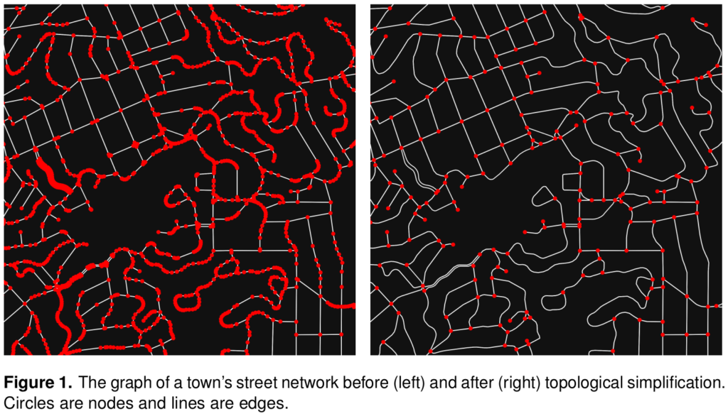
Street network topology simplification with OSMnx and OpenStreetMap

Categories
Data

GIS and Computational Notebooks

I have a new chapter “GIS and Computational Notebooks,” co-authored with Dani Arribas-Bel, out now in The Geographic Information Science & Technology Body of Knowledge. Want to make your spatial analyses more reproducible, portable, and well-documented? Our chapter is a short, gentle intro to using code and notebooks for modern GIS work.

Science and analytics both struggle with reproducibility, documentation, and portability. But GIS in both research and practice particularly suffers from these problems due to some of its unique characteristics. Our chapter discusses this challenge and its urgency for building better and more actionable knowledge from geospatial data. Then we introduce an emerging solution, the computational notebook, using Jupyter as our central example to illustrate what it does and how it works.

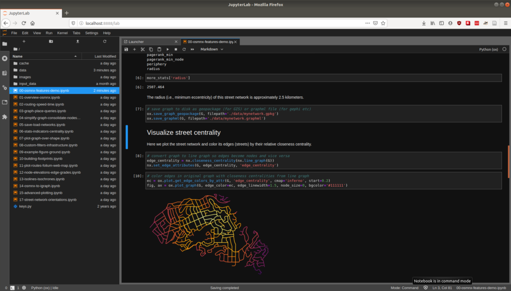
Jupyter notebook JupyterLab user interface

Categories
Data

New Article on Computational Notebooks

I have a new article out in Region: Journal of the European Regional Science Association, “Urban Street Network Analysis in a Computational Notebook.” It reflects on the use of Jupyter notebooks in applied data science research, pedagogy, and practice, and it uses the OSMnx examples repository as an example.

From the abstract:

Computational notebooks offer researchers, practitioners, students, and educators the ability to interactively conduct analytics and disseminate reproducible workflows that weave together code, visuals, and narratives. This article explores the potential of computational notebooks in urban analytics and planning, demonstrating their utility through a case study of OSMnx and its tutorials repository. OSMnx is a Python package for working with OpenStreetMap data and modeling, analyzing, and visualizing street networks anywhere in the world. Its official demos and tutorials are distributed as open-source Jupyter notebooks on GitHub. This article showcases this resource by documenting the repository and demonstrating OSMnx interactively through a synoptic tutorial adapted from the repository. It illustrates how to download urban data and model street networks for various study sites, compute network indicators, visualize street centrality, calculate routes, and work with other spatial data such as building footprints and points of interest. Computational notebooks help introduce methods to new users and help researchers reach broader audiences interested in learning from, adapting, and remixing their work. Due to their utility and versatility, the ongoing adoption of computational notebooks in urban planning, analytics, and related geocomputation disciplines should continue into the future.

For more, check out the article.

Categories
Urban

Big Data in Urban Morphology

My new article “Spatial Information and the Legibility of Urban Form: Big Data in Urban Morphology” has been published in the International Journal of Information Management (download free PDF). It builds on recent work by Crooks et al, presenting workflows to integrate data-driven and narrative approaches to urban morphology in today’s era of ubiquitous urban big data. It situates this theoretically in the visual culture of planning to present a visualization-mediated interpretative process of data-driven urban morphology, focusing on transportation infrastructure via OSMnx.

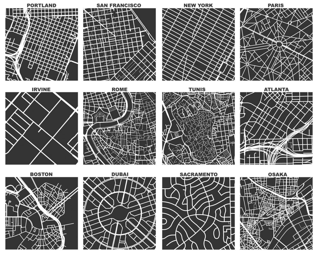
OSMnx: Figure-ground diagrams of one square mile of each street network, from OpenStreetMap, made in Python with matplotlib, geopandas, and NetworkX

Categories
Academia

Spring Teaching

Happy new year! In the spring semester I’ll be teaching two new courses: Big Data for Cities and Advanced Spatial Analysis of Urban Systems. The former serves as a sort of gateway course to Northeastern’s urban informatics master’s program, introducing students to urban theories and scientific methods of analyzing urban data. The latter introduces advanced students to a computational workflow of spatial analysis and statistics with Python, PostGIS, and other open-source tools. I’ll be creating my lectures as Jupyter notebooks and will share a GitHub link soon when they’re all together.

Categories
Academia

New Position at Northeastern

I’m happy to announce that I have accepted a tenure-track offer from Northeastern University as an assistant professor of urban informatics in the School of Public Policy and Urban Affairs, with a faculty affiliation in Northeastern’s Network Science Institute. I will be starting in the Fall and moving to Boston later this summer!