Categories
Tech

Global Healthy and Sustainable City Indicators

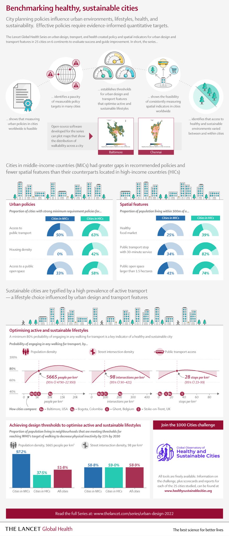
I recently co-authored an article, “Global Healthy and Sustainable City Indicators: Collaborative Development of an Open Science Toolkit for Calculating and Reporting on Urban Indicators Internationally,” now published in Environment and Planning B: Urban Analytics and City Science. This was a collaboration with my colleagues at the Global Observatory of Healthy and Sustainable Cities, in which we discuss our spatial software co-development process with collaborators and practitioners around the world.

From the abstract:

Measuring and monitoring progress towards achieving healthy, equitable and sustainable cities is a priority for planners, policymakers and researchers in diverse contexts globally. Yet data collection, analysis, visualisation and reporting on policy and spatial indicators involve specialised knowledge, skills, and collaboration across disciplines. Integrated open-source tools for calculating and communicating urban indicators for diverse urban contexts are needed, which provide the multiple streams of evidence required to influence policy agendas and enable local changes towards healthier and more sustainable cities. This paper reports on the development of open-source software for planning, analysis and generation of data, maps and reports on policy and spatial indicators of urban design and transport features for healthy and sustainable cities. We engaged a collaborative network of researchers and practitioners from diverse geographic contexts through an online survey and workshops, to understand and progressively meet their requirements for policy and spatial indicators. We outline our framework for action research-informed open-source software development and discuss benefits and challenges of this approach. The resulting Global Healthy and Sustainable City Indicators software is designed to meet the needs of researchers, planners, policy makers and community advocates in diverse settings for planning, calculating and disseminating policy and spatial urban indicators.

For more, check out the article.

Categories
Urban

The Lancet Global Health Series on Urban Design, Transport, and Health

After many years of hard work, our series of articles on urban design, transport, and health has been published by The Lancet Global Health.

The Lancet Global Health infographic on benchmarking healthy sustainable citiesIn our first paper, we analyzed urban policies and calculated built environment indicators for 25 cities across 6 continents to assess walkability and accessibility. Our policy analysis found policies inconsistent with public health evidence, rhetoric endorsing health and sustainability but few measurable policy targets, and substantial implementation gaps.

Categories
Data

OSMnx v1.2 Released

OSMnx v1.2.0 has been released. It includes several new features, bug fixes, and performance enhancements. I encourage you to upgrade and take advantage of everything new. For more information, check out the OSMnx documentation and usage examples for demonstrations of all you can do.

Categories
Data

OSMnx v1.1 Released

OSMnx v1.1.0 has been released. It includes several new features, bug fixes, and performance enhancements. I encourage you to upgrade and take advantage of everything new. I’ll summarize some of the key improvements in this post.

Categories
Data

GIS and Computational Notebooks

I have a new chapter “GIS and Computational Notebooks,” co-authored with Dani Arribas-Bel, out now in The Geographic Information Science & Technology Body of Knowledge. Want to make your spatial analyses more reproducible, portable, and well-documented? Our chapter is a short, gentle intro to using code and notebooks for modern GIS work.

Science and analytics both struggle with reproducibility, documentation, and portability. But GIS in both research and practice particularly suffers from these problems due to some of its unique characteristics. Our chapter discusses this challenge and its urgency for building better and more actionable knowledge from geospatial data. Then we introduce an emerging solution, the computational notebook, using Jupyter as our central example to illustrate what it does and how it works.

Jupyter notebook JupyterLab user interface

Categories
Academia

Geospatial Tool Building

My new article “The Right Tools for the Job: The Case for Spatial Science Tool-Building” has been published in Transactions in GIS (free PDF). I originally presented this paper as the 8th annual Transactions in GIS plenary address at the AAG annual meeting last year. I argue that tool-building is an essential but poorly incentivized component of academic geography and social science more broadly. To conduct better science, we need to build better tools. Better tools and data models, spearheaded by academics, can help infuse theory into our field’s quantitative work where it is too often lacking. But if we want better tools, we have to build them. It is not ESRI’s job to satisfy all the theoretical needs of the spatial sciences.