Categories
Planning

Robert Moses Responds to Robert Caro

In 1974, Robert Caro published The Power Broker, a critical biography of Robert Moses’s dictatorial tenure as the “master builder” of mid-century New York. Moses profoundly transformed New York’s urban fabric and transportation system, producing the Brooklyn Battery Tunnel, the Verrazano Narrows Bridge, the Westside Highway, the Cross-Bronx Expressway, the Lincoln Center, the UN headquarters, Shea Stadium, Jones Beach State Park and many other projects. However, The Power Broker did lasting damage to his public image and today he remains one of the most controversial figures in city planning history.

Today, The Power Broker may be the most well-known biography of any urban planner ever. Less-known: on August 26, 1974, Moses issued a turgid 23-page statement denouncing Caro’s work as “full of mistakes, unsupported charges, nasty baseless personalities, and random haymakers.” Moses’s original typewritten statement survives today as a grainy photocopy in the New York City Parks Department archive. To better preserve and disseminate it, I extracted and transcribed its text using optical character recognition and edited the result to correct errors. My transcription of Moses’s statement, alongside Caro’s response to it, is available here.
Categories
Urban

Urban Street Network Orientation

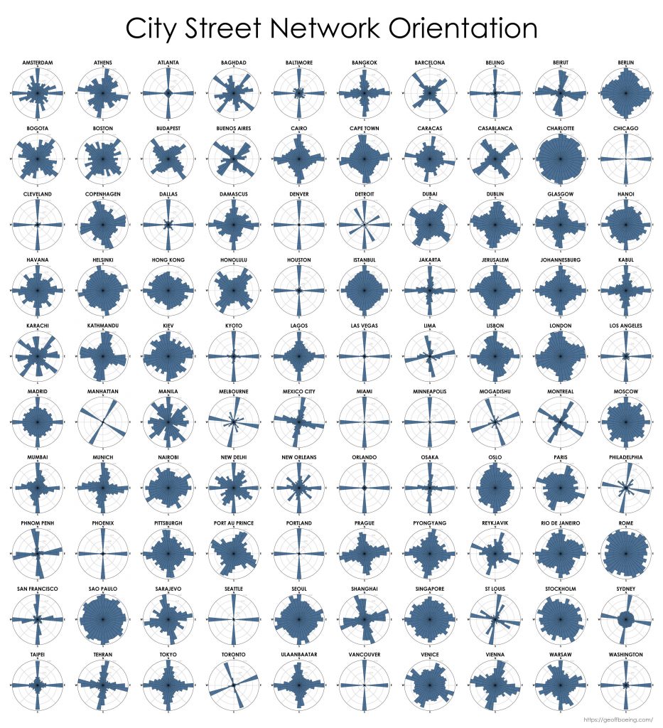
My new article, Urban Spatial Order: Street Network Orientation, Configuration, and Entropy, has just been published in one of my favorite journals: Applied Network Science (download free PDF). This study explores the spatial signatures of urban evolution and central planning. It examines street network orientation, connectivity, granularity, and entropy in 100 cities around the world using OpenStreetMap data and OSMnx for modeling and visualization:

City street network grid orientations, order, disorder, entropy, rose plot, polar histogram made with Python, OSMnx, OpenStreetMap, matplotlib.

So, who’s got a grid and who doesn’t? Each of the cities above is represented by a polar histogram (aka rose diagram) depicting how its streets orient. Each bar’s direction represents the compass bearings of the streets (in that histogram bin) and its length represents the relative frequency of streets with those bearings. The cities above are in alphabetical order. Here they are again, re-sorted from most-ordered/gridded city (Chicago) to most-disordered (Charlotte):

Categories
Planning

Comparing US City Street Orientations

City street network grid orientations, order, disorder, entropy, rose plot, polar histogram made with Python, OSMnx, OpenStreetMap, matplotlib.This post is adapted from this research paper that you can read/cite for more info. It analyzes and visualizes 100 cities around the world.

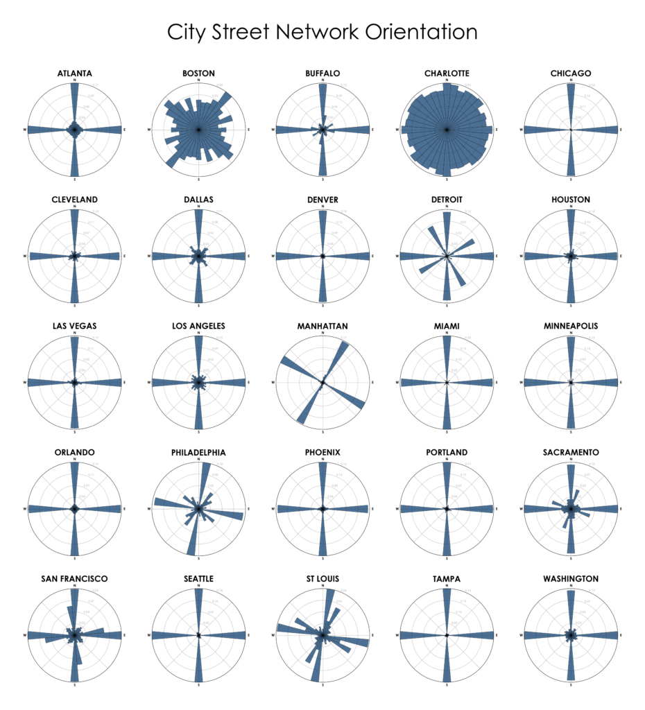
“We say the cows laid out Boston. Well, there are worse surveyors.” –Ralph Waldo Emerson. In 1960, one hundred years after Emerson’s quote, Kevin Lynch published The Image of the City, his treatise on the legibility of urban patterns. How coherent is a city’s spatial organization? How do these patterns help or hinder urban navigation? I recently wrote about visualizing street orientations with Python and OSMnx. That is, how is a city’s street network oriented in terms of the streets’ compass bearings? How well does it adhere to a straightforward north-south-east-west layout? I wanted to revisit this by comparing 25 major US cities’ orientations (EDIT: by popular request, see also this follow-up comparing world cities):

City street network grid orientations, rose plot, polar histogram made with Python, OSMnx, OpenStreetMap, matplotlib. Atlanta, Boston, Buffalo, Charlotte, Chicago, Cleveland, Dallas, Denver, Detroit, Houston, Las Vegas, Los Angeles, Manhattan, New York, Miami, Minneapolis, Orlando, Philadelphia, Phoenix, Portland, Sacramento, San Francisco, Seattle, St Louis, Tampa, Washington DC.

Categories
Planning

Urban Form Figure-Ground Diagrams

Check out the journal article about OSMnx.

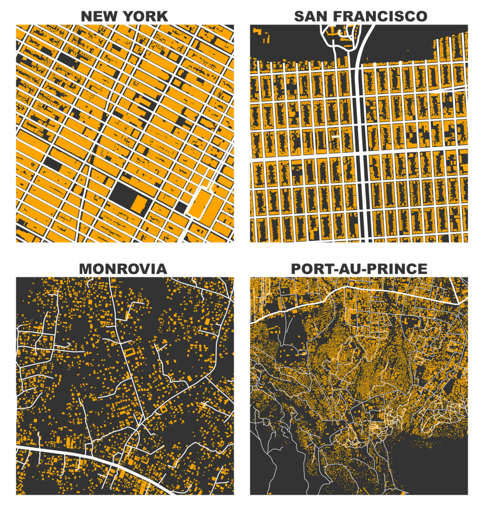
I previously demonstrated how to create figure-ground square-mile visualizations of urban street networks with OSMnx to consistently compare city patterns, design paradigms, and connectivity. OSMnx downloads, analyzes, and visualizes street networks from OpenStreetMap but it can also get building footprints. If we mash-up these building footprints with the street networks, we get a fascinating comparative window into urban form:

Figure-ground map of building footprints and street network in New York, San Francisco, Monrovia, and Port au Prince from OpenStreetMap data, created in Python with OSMnx