Categories
Planning

Air Pollution Exposure in Los Angeles

I have a new article out now in Urban Studies, which finds that—all else equal—residents of Los Angeles census tracts that generate more vehicular travel tend to be exposed to less vehicular air pollution, and that tracts with a larger non-white population proportion—whether high- or low-income—experience more air pollution than do whiter but otherwise similar tracts. There’s also a free, open access pre-print available.

Twentieth century planners designed and constructed an enormous network of expressways to open up growing American metropolises to motorists. Vast swaths of established urban neighborhoods were bulldozed to clear new channels for suburban residents to drive to job centers. Yet some older neighborhoods survived relatively unscathed.

For example, in Los Angeles, local residents organized to protest and eventually successfully cancel plans to extend State Route 2 through the affluent communities of Beverly Hills and Los Angeles’s westside. In contrast, similar grassroots efforts failed in Los Angeles’s eastside, where several major freeways carved up its less-affluent and less-white neighborhoods.
Categories
Urban

Urban Street Network Orientation

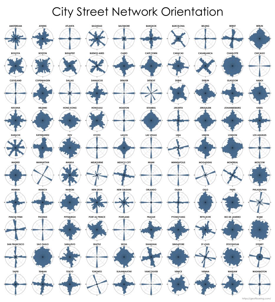
My new article, Urban Spatial Order: Street Network Orientation, Configuration, and Entropy, has just been published in one of my favorite journals: Applied Network Science (download free PDF). This study explores the spatial signatures of urban evolution and central planning. It examines street network orientation, connectivity, granularity, and entropy in 100 cities around the world using OpenStreetMap data and OSMnx for modeling and visualization:

City street network grid orientations, order, disorder, entropy, rose plot, polar histogram made with Python, OSMnx, OpenStreetMap, matplotlib.

So, who’s got a grid and who doesn’t? Each of the cities above is represented by a polar histogram (aka rose diagram) depicting how its streets orient. Each bar’s direction represents the compass bearings of the streets (in that histogram bin) and its length represents the relative frequency of streets with those bearings. The cities above are in alphabetical order. Here they are again, re-sorted from most-ordered/gridded city (Chicago) to most-disordered (Charlotte):

Categories
Academia

New Position at USC

I’m happy to announce that I have accepted a tenure-track offer from the University of Southern California as an assistant professor in the Sol Price School’s Department of Urban Planning and Spatial Analysis. I will be starting in the Fall and moving to Los Angeles later this summer! Looking forward to heading back home to California.

Categories
Planning

Comparing US City Street Orientations

City street network grid orientations, order, disorder, entropy, rose plot, polar histogram made with Python, OSMnx, OpenStreetMap, matplotlib.This post is adapted from this research paper that you can read/cite for more info. It analyzes and visualizes 100 cities around the world.

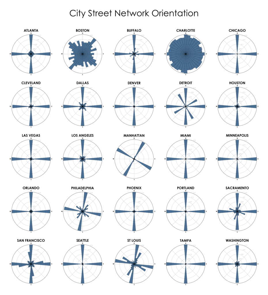
“We say the cows laid out Boston. Well, there are worse surveyors.” –Ralph Waldo Emerson. In 1960, one hundred years after Emerson’s quote, Kevin Lynch published The Image of the City, his treatise on the legibility of urban patterns. How coherent is a city’s spatial organization? How do these patterns help or hinder urban navigation? I recently wrote about visualizing street orientations with Python and OSMnx. That is, how is a city’s street network oriented in terms of the streets’ compass bearings? How well does it adhere to a straightforward north-south-east-west layout? I wanted to revisit this by comparing 25 major US cities’ orientations (EDIT: by popular request, see also this follow-up comparing world cities):

City street network grid orientations, rose plot, polar histogram made with Python, OSMnx, OpenStreetMap, matplotlib. Atlanta, Boston, Buffalo, Charlotte, Chicago, Cleveland, Dallas, Denver, Detroit, Houston, Las Vegas, Los Angeles, Manhattan, New York, Miami, Minneapolis, Orlando, Philadelphia, Phoenix, Portland, Sacramento, San Francisco, Seattle, St Louis, Tampa, Washington DC.