Categories
Planning

Rethinking the One-Way Street

I recently published an article in Transfers Magazine with Billy Riggs questioning some of the received wisdom about one-way streets and efficiency. This builds on our recent research published in JPER modeling vehicle distance traveled before and after hypothetical one-way to two-way street conversions.

Categories
Planning

ISPAH in Abu Dhabi

Alongside Billie Giles-Corti and Jim Sallis, I will be presenting our team’s recent research into accessible, sustainable urban design around the world at the ISPAH Congress in Abu Dhabi this week. Our symposium at the congress will share the methods and findings from our The Lancet Global Health series published this summer, as well as our ongoing work on the Thousand Cities Challenge.

Our geospatial team developed open-source software to calculate indicators of walkability and accessibility around the world, and then linked these back to cities’ policy contexts and identified populations living above and below estimated thresholds for physical activity. Few cities had measurable policy standards and targets to actually build healthier and more sustainable cities, and their health-supportive built environment features were often inadequate or inequitably distributed.

We simultaneously launched the Global Observatory of Healthy and Sustainable Cities to promote healthy and sustainable urban planning, benchmark and monitor cities’ progress, and share more consistent, comparable urban data. The whole series of articles is free and open access, as is our software.

Categories
Planning

Framework for Measuring Pedestrian Accessibility

I’m a co-author of a new article, “A Generalized Framework for Measuring Pedestrian Accessibility around the World Using Open Data,” which has just been published by Geographical Analysis. We developed an open source, containerized software framework for modeling pedestrian networks using open data to analyze disaggregate access to daily living needs. We worked with local partners in 25 cities around the world to demonstrate and validate this toolkit.

From the abstract:

Pedestrian accessibility is an important factor in urban transport and land use policy and critical for creating healthy, sustainable cities. Developing and evaluating indicators measuring inequalities in pedestrian accessibility can help planners and policymakers benchmark and monitor the progress of city planning interventions. However, measuring and assessing indicators of urban design and transport features at high resolution worldwide to enable city comparisons is challenging due to limited availability of official, high quality, and comparable spatial data, as well as spatial analysis tools offering customizable frameworks for indicator construction and analysis. To address these challenges, this study develops an open source software framework to construct pedestrian accessibility indicators for cities using open and consistent data. It presents a generalized method to consistently measure pedestrian accessibility at high resolution and spatially aggregated scale, to allow for both within- and between-city analyses. The open source and open data methods developed in this study can be extended to other cities worldwide to support local planning and policymaking. The software is made publicly available for reuse in an open repository.

For more, check out the article.

Categories
Data

Worldwide Street Network Models and Indicators

My article, “Street Network Models and Indicators for Every Urban Area in the World” has been published by Geographical Analysis. This project was a massive undertaking and I’m excited to share it. As you might guess from the title, I modeled and analyzed the street network of each urban area in the world then deposited all the source code and models and indicators in open repositories for public reuse. The article also includes a high-level analysis of urban street network form across the world.

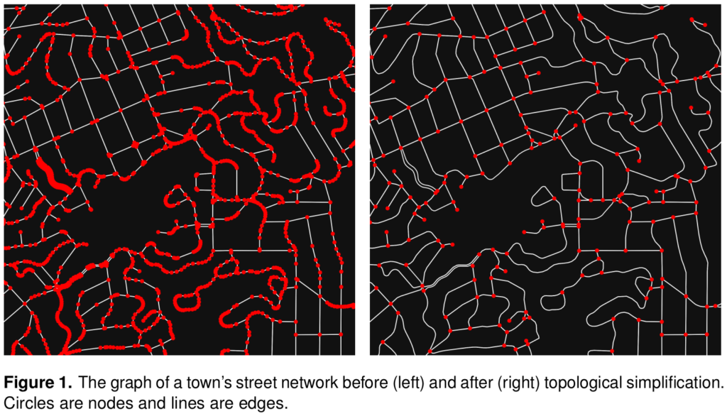
Cities worldwide exhibit a variety of street patterns and configurations that shape human mobility, equity, health, and livelihoods. Using boundaries derived from the Global Human Settlement Layer, I modeled and analyzed the street networks of every urban area in the world using OSMnx and OpenStreetMap raw data. In total, I modeled over 160 million street network nodes and over 320 million edges across 8,914 urban areas in 178 countries. I attached node elevations and street grades to every node/edge in the final models. All the final models were topologically simplified such that nodes represent intersections and dead-ends, and edges represent the street segments linking them.

Street network topology simplification with OSMnx and OpenStreetMap

Categories
Data

New Article on Computational Notebooks

I have a new article out in Region: Journal of the European Regional Science Association, “Urban Street Network Analysis in a Computational Notebook.” It reflects on the use of Jupyter notebooks in applied data science research, pedagogy, and practice, and it uses the OSMnx examples repository as an example.

From the abstract:

Computational notebooks offer researchers, practitioners, students, and educators the ability to interactively conduct analytics and disseminate reproducible workflows that weave together code, visuals, and narratives. This article explores the potential of computational notebooks in urban analytics and planning, demonstrating their utility through a case study of OSMnx and its tutorials repository. OSMnx is a Python package for working with OpenStreetMap data and modeling, analyzing, and visualizing street networks anywhere in the world. Its official demos and tutorials are distributed as open-source Jupyter notebooks on GitHub. This article showcases this resource by documenting the repository and demonstrating OSMnx interactively through a synoptic tutorial adapted from the repository. It illustrates how to download urban data and model street networks for various study sites, compute network indicators, visualize street centrality, calculate routes, and work with other spatial data such as building footprints and points of interest. Computational notebooks help introduce methods to new users and help researchers reach broader audiences interested in learning from, adapting, and remixing their work. Due to their utility and versatility, the ongoing adoption of computational notebooks in urban planning, analytics, and related geocomputation disciplines should continue into the future.

For more, check out the article.

Categories
Urban

New Article: Complexity in Urban Form and Design

My article, Measuring the Complexity of Urban Form and Design, is now in-press for publication at Urban Design International (download free PDF). Cities are complex systems composed of many human agents interacting in physical urban space. This paper develops a typology of measures and indicators for assessing the physical complexity of the built environment at the scale of urban design. It extends quantitative measures from city planning, network science, ecosystems studies, fractal geometry, statistical physics, and information theory to the analysis of urban form and qualitative human experience.

The Mandelbrot set, a mathematical fractal. Venice's fractal urban form and fabric. The Eiffel Tower's fractal architecture in Paris.