Categories
Data

OSMnx 2.0 Released

OSMnx version 2.0.0 has been released. This has been a massive effort over the past year to streamline the package’s API, re-think its internal organization, and optimize its code. Today OSMnx is faster, more memory efficient, and fully type-annotated for a better user experience.

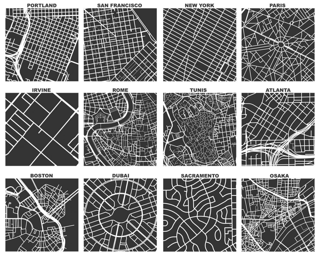
If you haven’t used it before, OSMnx is a Python package to easily download, model, analyze, and visualize street networks and any other geospatial features from OpenStreetMap. You can download and model walking, driving, or biking networks with a single line of code then quickly analyze and visualize them. You can just as easily work with urban amenities/points of interest, building footprints, transit stops, elevation data, street orientations, speed/travel time, and routing.OSMnx: Figure-ground diagrams of one square mile of each street network, from OpenStreetMap, made in Python with matplotlib, geopandas, and NetworkXThis has now been a labor of love for me for about 9 years. Wow. I initially developed this package to enable the empirical research for my dissertation. Since then, it has powered probably 2/3 of the articles I’ve published over the years. And it has received hundreds of contributions from many other code contributors. Thank you to everyone who helped make this possible.

I hope you find the package as useful as I do. Now I’m looking forward to all of your bug reports.

Categories
Academia

Access to the Exclusive City

I recently coauthored an article in Urban Studies with Julia Harten titled “Access to the Exclusive City: Home Sharing as an Affordable Housing Strategy.” We examined how shared housing serves increasingly diverse populations as a pathway into otherwise unaffordable housing submarkets.

From the abstract:

Home sharing, particularly via online platforms, is becoming a mainstream housing strategy as social processes evolve and housing costs rise. Recent research has studied shared rentals as a modality for students and kin-based households, as one strategy among diversifying pathways to housing and as a social phenomenon. However, we still know little about whether it actually creates opportunities for home seekers in unaffordable markets. Analysing online rental listings in Los Angeles, we find that shared rentals are both more affordable and more widely available across diverse neighbourhoods than traditional whole-unit rentals. Shared rentals have historically been understudied due to their limited data trail, but they offer important entryways into unaffordable markets. We argue for shared housing research to shift its traditional focus away from students and young adults and towards a broader exploration of the diverse populations that may benefit from or depend on shared housing.

For more, check out the article.

Categories
Uncategorized

A Roadmap for Data-Driven Urban Research

I recently coauthored an article in the journal Cities titled “A Road Map for Future Data-Driven Urban Planning and Environmental Health Research.” This arose from a symposium in Sitges, Spain which I was invited to last year by the Barcelona Institute for Global Health.

From the abstract:

Recent advances in data science and urban environmental health research utilise large-scale databases (100s–1000s of cities) to explore the complex interplay of urban characteristics such as city form and size, climate, mobility, exposure, and environmental health impacts. Cities are still hotspots of air pollution and noise, suffer urban heat island effects and lack of green space, which leads to disease and mortality burdens preventable with better knowledge. Better understanding through harmonising and analysing data in large numbers of cities is essential to identifying the most effective means of disease prevention and understanding context dependencies important for policy.

For more, check out the article.

Categories
Academia

The Structure of Street Networks

I recently coauthored an article titled “A Review of the Structure of Street Networks” with Marc Barthelemy in Transport Findings. On a personal note, Marc has long been a personal hero of mine and was the 2nd most cited author in my dissertation, after Mike Batty (who I also recently had the pleasure of collaborating with).

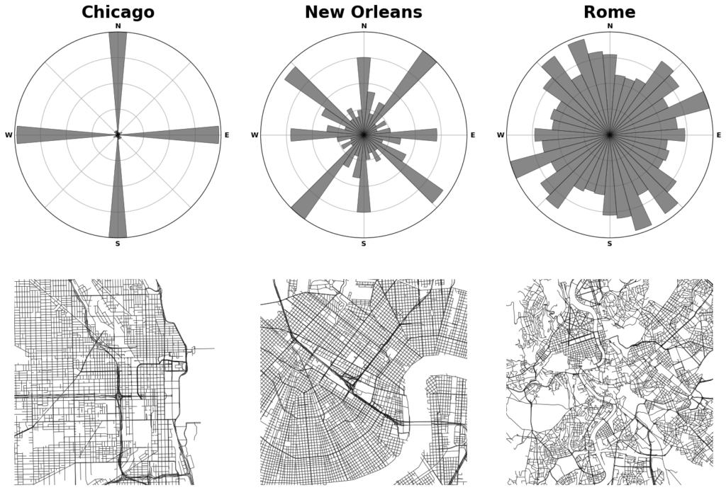
Street network orientation in Chicago (low entropy), New Orleans (medium entropy), and Rome (high entropy) with polar histograms.From the abstract:

We review measures of street network structure proposed in the recent literature, establish their relevance to practice, and identify open challenges facing researchers. These measures’ empirical values vary substantially across world regions and development eras, indicating street networks’ geometric and topological heterogeneity.

For more, check out the article.

Categories
Data

OSMnx 2.0 Beta

OSMnx v2.0.0 is targeted for release later in 2024. This major release includes some breaking changes (including removing previously deprecated functionality) that are not backwards compatible with v1. See the migration guide and reference paper for details.

The first beta pre-release is out now, and testers are needed. If you use OSMnx, you can help test it by installing the latest pre-release. Create a virtual environment then run: pip install --pre osmnx

For more, check out the migration guide and reference paper.

Categories
Planning

Resilient by Design

I have a new article out now in Transportation Research Part A: Policy and Practice. Here’s a free open-access preprint if you lack institutional access.

We simulate over 2.4 billion trips across every urban area in the world to measure street network vulnerability to disasters, then measure the relationships between street network design and these vulnerability indicators.

First we modeled the street networks of more than 8,000 urban areas in 178 countries. Then, for each urban area, we simulated disasters of 3 different types (representing floods, earthquakes, and targeted attacks) and 10 different extents. Then we simulated over 2.4 billion trips on these networks to measure how certain trips become more circuitous or even impossible to complete as parts of the network fail after a disaster. Finally we built a model to predict how much a disaster would impact trips.

Categories
Planning

Street Network Design and GHG Emissions

I have a new article out in Transportation Research Part D that estimates relationships between street network characteristics and transport CO2 emissions across every urban area in the world and investigates whether they are the same across development levels and design paradigms.

The relationships between street network design and transport emissions in the US, Europe, and China are well-studied. But not so in many of the most rapidly developing parts of the world. Practitioners lack a strong local evidence base for local evidence-informed planning.

Categories
Planning

Rethinking the One-Way Street

I recently published an article in Transfers Magazine with Billy Riggs questioning some of the received wisdom about one-way streets and efficiency. This builds on our recent research published in JPER modeling vehicle distance traveled before and after hypothetical one-way to two-way street conversions.

Categories
Planning

Air Pollution Exposure in Los Angeles

I have a new article out now in Urban Studies, which finds that—all else equal—residents of Los Angeles census tracts that generate more vehicular travel tend to be exposed to less vehicular air pollution, and that tracts with a larger non-white population proportion—whether high- or low-income—experience more air pollution than do whiter but otherwise similar tracts. There’s also a free, open access pre-print available.

Twentieth century planners designed and constructed an enormous network of expressways to open up growing American metropolises to motorists. Vast swaths of established urban neighborhoods were bulldozed to clear new channels for suburban residents to drive to job centers. Yet some older neighborhoods survived relatively unscathed.

For example, in Los Angeles, local residents organized to protest and eventually successfully cancel plans to extend State Route 2 through the affluent communities of Beverly Hills and Los Angeles’s westside. In contrast, similar grassroots efforts failed in Los Angeles’s eastside, where several major freeways carved up its less-affluent and less-white neighborhoods.

Categories
Data

Urban Analytics: History, Trajectory and Critique

I have a new chapter titled “Urban Analytics: History, Trajectory and Critique,” co-authored with Mike Batty, Shan Jiang, and Lisa Schweitzer, now published in the Handbook of Spatial Analysis in the Social Sciences, edited by Serge Rey and Rachel Franklin.

From our abstract:

Urban analytics combines spatial analysis, statistics, computer science, and urban planning to understand and shape city futures. While it promises better policymaking insights, concerns exist around its epistemological scope and impacts on privacy, ethics, and social control. This chapter reflects on the history and trajectory of urban analytics as a scholarly and professional discipline. In particular, it considers the direction in which this field is going and whether it improves our collective and individual welfare. It first introduces early theories, models, and deductive methods from which the field originated before shifting toward induction. It then explores urban network analytics that enrich traditional representations of spatial interaction and structure. Next it discusses urban applications of spatiotemporal big data and machine learning. Finally, it argues that privacy and ethical concerns are too often ignored as ubiquitous monitoring and analytics can empower social repression. It concludes with a call for a more critical urban analytics that recognizes its epistemological limits, emphasizes human dignity, and learns from and supports marginalized communities.

For more, check out the chapter.