Categories
Data

OSMnx 2.0 Released

OSMnx version 2.0.0 has been released. This has been a massive effort over the past year to streamline the package’s API, re-think its internal organization, and optimize its code. Today OSMnx is faster, more memory efficient, and fully type-annotated for a better user experience.

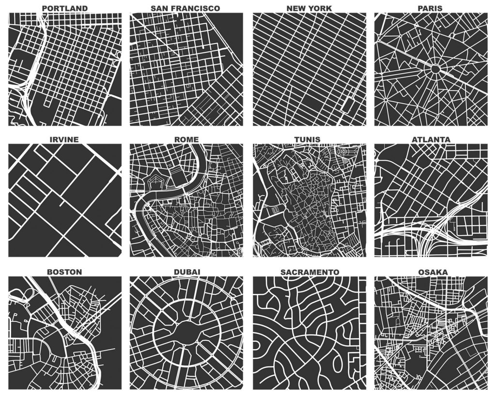
If you haven’t used it before, OSMnx is a Python package to easily download, model, analyze, and visualize street networks and any other geospatial features from OpenStreetMap. You can download and model walking, driving, or biking networks with a single line of code then quickly analyze and visualize them. You can just as easily work with urban amenities/points of interest, building footprints, transit stops, elevation data, street orientations, speed/travel time, and routing.OSMnx: Figure-ground diagrams of one square mile of each street network, from OpenStreetMap, made in Python with matplotlib, geopandas, and NetworkXThis has now been a labor of love for me for about 9 years. Wow. I initially developed this package to enable the empirical research for my dissertation. Since then, it has powered probably 2/3 of the articles I’ve published over the years. And it has received hundreds of contributions from many other code contributors. Thank you to everyone who helped make this possible.

I hope you find the package as useful as I do. Now I’m looking forward to all of your bug reports.

Categories
Academia

The Structure of Street Networks

I recently coauthored an article titled “A Review of the Structure of Street Networks” with Marc Barthelemy in Transport Findings. On a personal note, Marc has long been a personal hero of mine and was the 2nd most cited author in my dissertation, after Mike Batty (who I also recently had the pleasure of collaborating with).

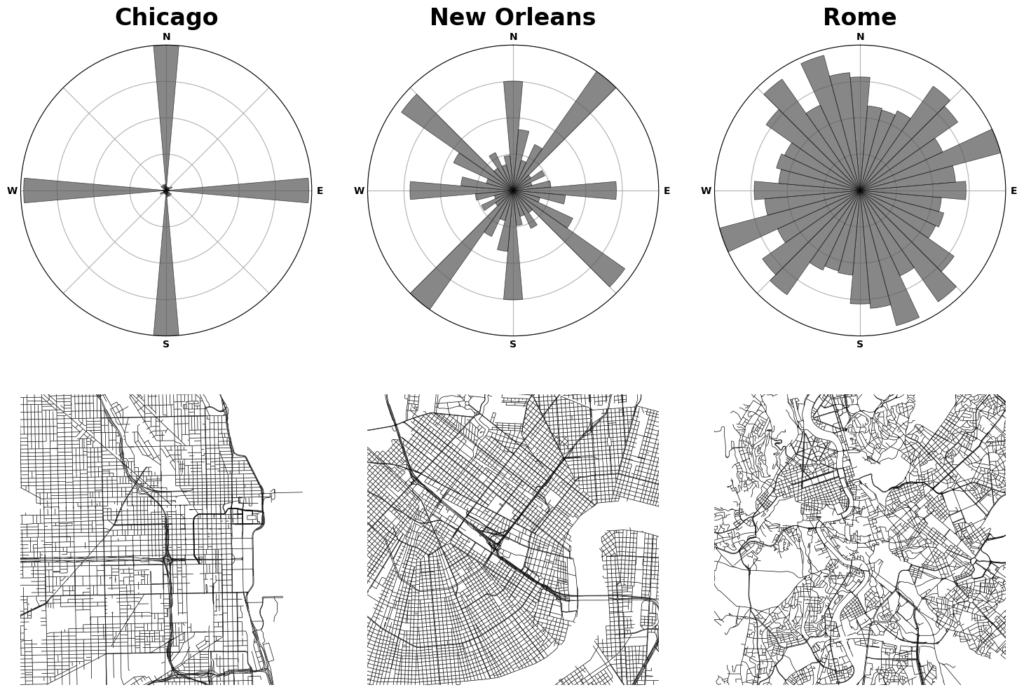
Street network orientation in Chicago (low entropy), New Orleans (medium entropy), and Rome (high entropy) with polar histograms.From the abstract:

We review measures of street network structure proposed in the recent literature, establish their relevance to practice, and identify open challenges facing researchers. These measures’ empirical values vary substantially across world regions and development eras, indicating street networks’ geometric and topological heterogeneity.

For more, check out the article.

Categories
Academia

AI and NLP for Urban Mixed Methods Research

One area where urban AI research seems promising is in mixed methods work. For example, it’s hard to use traditional qualitative methods on really large text data sets because of the overwhelming manual labor involved. But if you could train a model to do, say, topic labeling for you, you’d be able to (potentially) analyze nearly unlimited text data nearly instantly after that initial training work. The mixed methods holy grail.

I coauthored an article recently in Computers, Environment and Urban Systems with Madison Lore and Julia Harten which takes up this challenge. Using Los Angeles’s housing crisis and rental market as a case study, we demonstrate how and when modern AI and NLP techniques can generate qualitative insights on par with traditional manual techniques, but at a far larger scale and requiring far less labor.

Categories
Data

OSMnx 2.0 Beta

OSMnx v2.0.0 is targeted for release later in 2024. This major release includes some breaking changes (including removing previously deprecated functionality) that are not backwards compatible with v1. See the migration guide and reference paper for details.

The first beta pre-release is out now, and testers are needed. If you use OSMnx, you can help test it by installing the latest pre-release. Create a virtual environment then run: pip install --pre osmnx

For more, check out the migration guide and reference paper.

Categories
Planning

Delivering Healthy and Sustainable Cities

I have a new article out now in The Journal of City Climate Policy and Economy, coauthored with a team that includes several of the folks from our recent series in The Lancet Global Health. The JCCPE article, “A Pathway to Prioritizing and Delivering Healthy and Sustainable Cities,” synthesizes findings and recommended policy actions arising from that recent TLGH series.

From the abstract:

Creating healthy and sustainable cities should be a global priority. Some cities prioritize 15-minute cities as a planning approach with co-benefits for health, climate change mitigation, equity, and economic recovery from COVID-19. Yet, as our recent The Lancet Global Health series on “Urban Design, Transport, and Health” showed, many cities have a long way to go to achieve this vision. This policy guideline summarizes the main findings of the series, which assessed health and sustainability indicators for 25 cities in 19 countries. We then outline steps governments can take to strengthen policy frameworks and deliver more healthy, equitable, and sustainable built environments. The Lancet Global Health series provided clear evidence that cities need to transform urban governance to enable integrated planning for health and sustainability and commit to policy implementation. Evidence-informed indicators should be used to benchmark and monitor progress. Cities need policy frameworks that are comprehensive and consistent with evidence, with measurable policy targets to support implementation and accountability. The series provided evidence-informed thresholds for some key urban design and transport features, which can be embedded as policy targets. Policies and interventions must prioritize identifying and reducing inequities in access to health-supportive environments. Governments should also invest in open data and promote citizen-science programmes, to support indicator development and research for public benefit. We provide tools to replicate our indicators and an invitation to join our 1,000 Cities Challenge via the Global Observatory of Healthy and Sustainable Cities.

For more, check out the JCCPE article itself. And you may also be interested in our recent The Lancet Global Health series of articles that developed similar themes in great depth.

Categories
Planning

ISPAH in Abu Dhabi

Alongside Billie Giles-Corti and Jim Sallis, I will be presenting our team’s recent research into accessible, sustainable urban design around the world at the ISPAH Congress in Abu Dhabi this week. Our symposium at the congress will share the methods and findings from our The Lancet Global Health series published this summer, as well as our ongoing work on the Thousand Cities Challenge.

Our geospatial team developed open-source software to calculate indicators of walkability and accessibility around the world, and then linked these back to cities’ policy contexts and identified populations living above and below estimated thresholds for physical activity. Few cities had measurable policy standards and targets to actually build healthier and more sustainable cities, and their health-supportive built environment features were often inadequate or inequitably distributed.

We simultaneously launched the Global Observatory of Healthy and Sustainable Cities to promote healthy and sustainable urban planning, benchmark and monitor cities’ progress, and share more consistent, comparable urban data. The whole series of articles is free and open access, as is our software.

Categories
Urban

The Lancet Global Health Series on Urban Design, Transport, and Health

After many years of hard work, our series of articles on urban design, transport, and health has been published by The Lancet Global Health.

The Lancet Global Health infographic on benchmarking healthy sustainable citiesIn our first paper, we analyzed urban policies and calculated built environment indicators for 25 cities across 6 continents to assess walkability and accessibility. Our policy analysis found policies inconsistent with public health evidence, rhetoric endorsing health and sustainability but few measurable policy targets, and substantial implementation gaps.

Categories
Data

OSMnx v1.2 Released

OSMnx v1.2.0 has been released. It includes several new features, bug fixes, and performance enhancements. I encourage you to upgrade and take advantage of everything new. For more information, check out the OSMnx documentation and usage examples for demonstrations of all you can do.

Categories
Planning

Framework for Measuring Pedestrian Accessibility

I’m a co-author of a new article, “A Generalized Framework for Measuring Pedestrian Accessibility around the World Using Open Data,” which has just been published by Geographical Analysis. We developed an open source, containerized software framework for modeling pedestrian networks using open data to analyze disaggregate access to daily living needs. We worked with local partners in 25 cities around the world to demonstrate and validate this toolkit.

From the abstract:

Pedestrian accessibility is an important factor in urban transport and land use policy and critical for creating healthy, sustainable cities. Developing and evaluating indicators measuring inequalities in pedestrian accessibility can help planners and policymakers benchmark and monitor the progress of city planning interventions. However, measuring and assessing indicators of urban design and transport features at high resolution worldwide to enable city comparisons is challenging due to limited availability of official, high quality, and comparable spatial data, as well as spatial analysis tools offering customizable frameworks for indicator construction and analysis. To address these challenges, this study develops an open source software framework to construct pedestrian accessibility indicators for cities using open and consistent data. It presents a generalized method to consistently measure pedestrian accessibility at high resolution and spatially aggregated scale, to allow for both within- and between-city analyses. The open source and open data methods developed in this study can be extended to other cities worldwide to support local planning and policymaking. The software is made publicly available for reuse in an open repository.

For more, check out the article.

Categories
Data

OSMnx v1.1 Released

OSMnx v1.1.0 has been released. It includes several new features, bug fixes, and performance enhancements. I encourage you to upgrade and take advantage of everything new. I’ll summarize some of the key improvements in this post.