Categories
Academia

Geospatial Tool Building

My new article “The Right Tools for the Job: The Case for Spatial Science Tool-Building” has been published in Transactions in GIS (free PDF). I originally presented this paper as the 8th annual Transactions in GIS plenary address at the AAG annual meeting last year. I argue that tool-building is an essential but poorly incentivized component of academic geography and social science more broadly. To conduct better science, we need to build better tools. Better tools and data models, spearheaded by academics, can help infuse theory into our field’s quantitative work where it is too often lacking. But if we want better tools, we have to build them. It is not ESRI’s job to satisfy all the theoretical needs of the spatial sciences.

Categories
Data

OSMnx Summer Wrap-Up

OSMnx underwent a major overhaul this summer, with the development of several new features, improvements, and optimizations. This project concluded yesterday with the release of v0.16.0.

This post briefly summarizes what’s changed since the previous mid-summer updates. It covers the new k shortest paths solver, auto-selecting the first polygon when geocoding, better conversion of graph types, and the new geometries module that lets you flexibly download any OSM geospatial objects as a geopandas GeoDataFrame.

Categories
Data

Street Network Analysis in a Docker Container

Containerization is the way of the future present. I’ve heard feedback from some folks over the past few months who would like to play around with OSMnx for street network analysis, transport modeling, and urban design—but can’t because they can’t install Python and its data science stack on their computers. Furthermore, it would be nice to have a consistent reference environment to deploy on AWS or elsewhere in the cloud.

So, I’ve created a docker image containing OSMnx, Jupyter, and the rest of the Python geospatial data science stack, available on docker hub alongside additional usage instructions. If you’re starting from scratch, you can get started in four simple steps:

Categories
Planning

Estimating Daytime Density in RSRS

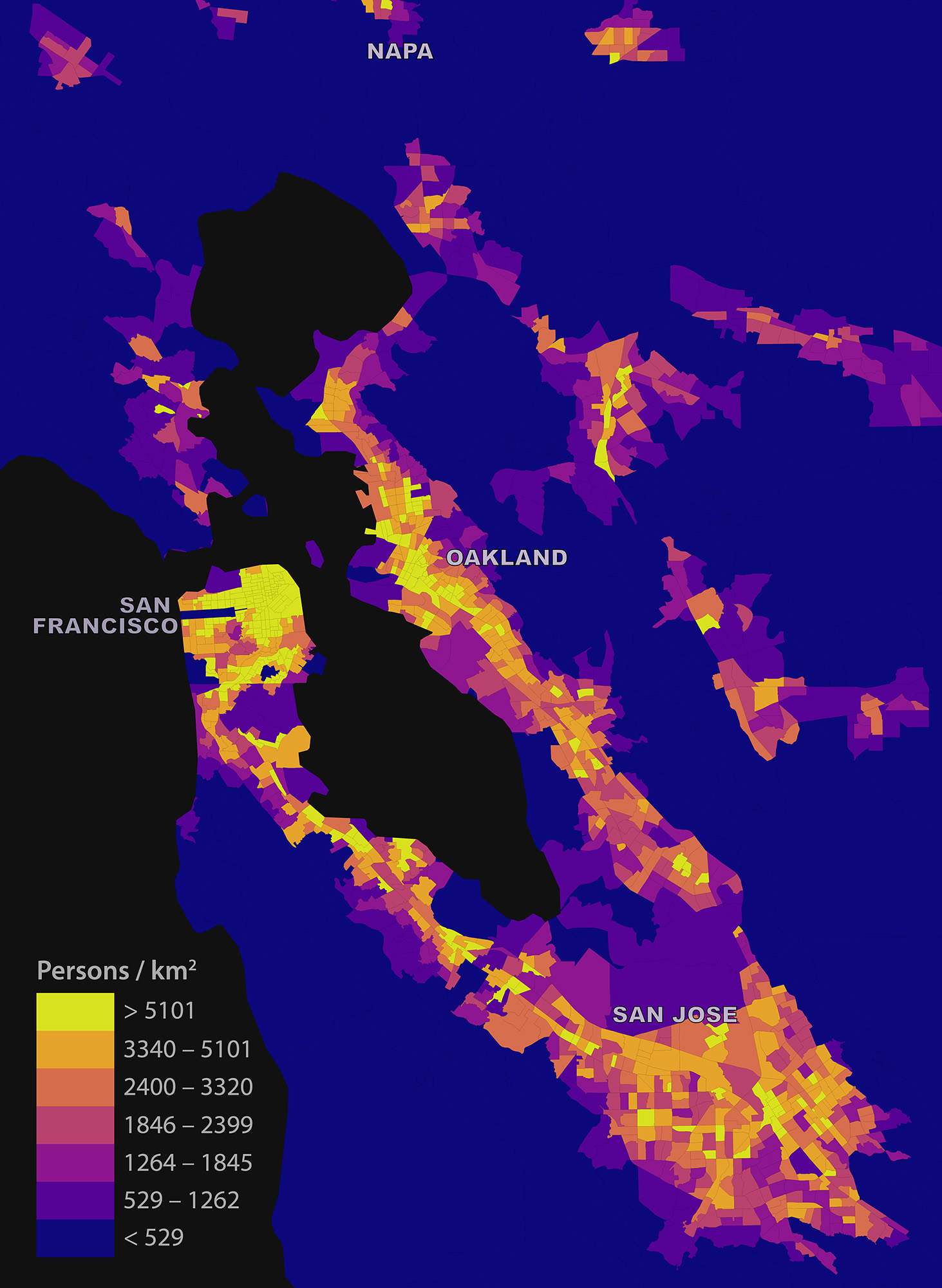
My short article “Estimating Local Daytime Population Density from Census and Payroll Data” is out now in the latest issue of Regional Studies, Regional Science. I discuss a method for estimating local daytime density across a metropolitan area using US Census and LEHD LODES data, and dig into some limitations and biases. I look at the San Francisco Bay Area as a case study:

Map of the estimated daytime population density in the San Francisco Bay Area

Categories
Data

OSMnx Features Round-Up

OSMnx is a Python package for quickly and easily downloading, modeling, analyzing, and visualizing street networks and other spatial data from OpenStreetMap. Here’s a quick round-up of recent updates to OSMnx. I’ll try to keep this up to date as a single reference source. A lot of new features have appeared in the past few months, and people have been asking about what’s new and what’s possible. You can:

  • Download and model street networks or other networked infrastructure anywhere in the world with a single line of code
  • Download any other spatial geometries, place boundaries, building footprints, or points of interest as a GeoDataFrame
  • Download by city name, polygon, bounding box, or point/address + network distance
  • Download drivable, walkable, bikeable, or all street networks
  • Download node elevations and calculate edge grades (inclines)
  • Impute missing speeds and calculate graph edge travel times
  • Simplify and correct the network’s topology to clean-up nodes and consolidate intersections
  • Fast map-matching of points, routes, or trajectories to nearest graph edges or nodes
  • Save networks to disk as shapefiles, geopackages, and GraphML
  • Save/load street network to/from a local .osm xml file
  • Conduct topological and spatial analyses to automatically calculate dozens of indicators
  • Calculate and visualize street bearings and orientations
  • Calculate and visualize shortest-path routes that minimize distance, travel time, elevation, etc
  • Visualize street networks as a static map or interactive leaflet web map
  • Visualize travel distance and travel time with isoline and isochrone maps
  • Plot figure-ground diagrams of street networks and building footprints
Categories
Academia

New Article: OSMnx in CEUS

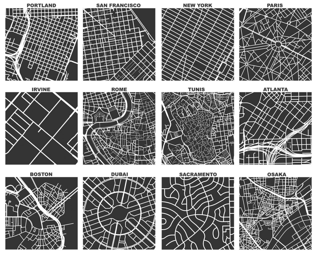
My article “OSMnx: New methods for acquiring, constructing, analyzing, and visualizing complex street networks” was published in the journal Computers, Environment and Urban Systems earlier this month. OSMnx is a Python package that lets you download a street network anywhere in the world at any scale with a single line of code, then analyze or visualize it with one more line of code.

OSMnx: Figure-ground diagrams of one square mile of each street network, from OpenStreetMap, made in Python with matplotlib, geopandas, and NetworkX

Categories
Data

OSMnx and Street Network Elevation Data

Check out the journal article about OSMnx.

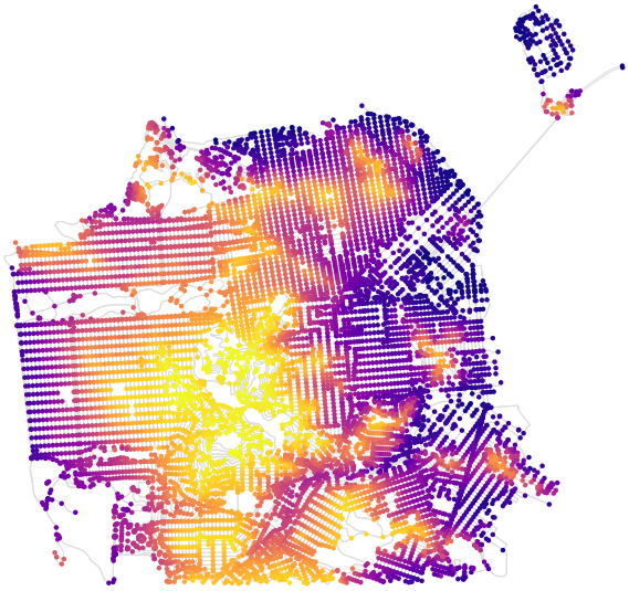
OSMnx can now download street network elevation data for anywhere in the world. In one line of code it downloads the elevation in meters of each network node, and in one more line of code it can calculate every street (i.e., edge) grade. Here is the complete street network of San Francisco, California, with nodes colored according to their elevation:

OSMnx street network elevation data for San Francisco, California to calculate street grade and steepness

Categories
Planning

Urban Form Analysis with OpenStreetMap Data

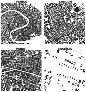
Figure-ground diagrams of urban form and building footprints in London, Paris, Venice, and Brasilia depict modernism's inversion of traditional spatial orderCheck out the journal article about OSMnx. This is a summary of some of my recent research on making OpenStreetMap data analysis easy for urban planners. It was also published on the ACSP blog.

OpenStreetMap – a collaborative worldwide mapping project inspired by Wikipedia – has emerged in recent years as a major player both for mapping and acquiring urban spatial data. Though coverage varies somewhat worldwide, its data are of high quality and compare favorably to CIA World Factbook estimates and US Census TIGER/Line data. OpenStreetMap imported the TIGER/Line roads in 2007 and since then its community has made numerous corrections and improvements. In fact, many of these additions go beyond TIGER/Line’s scope, including for example passageways between buildings, footpaths through parks, bike routes, and detailed feature attributes such as finer-grained street classifiers, speed limits, etc.

This presents a fantastic data source to help answer urban planning questions, but OpenStreetMap’s data has been somewhat difficult to work with due to its Byzantine query language and coarse-grained bulk extracts provided by third parties. As part of my dissertation, I developed a tool called OSMnx that allows researchers to download street networks and building footprints for any city name, address, or polygon in the world, then analyze and visualize them. OSMnx democratizes these data and methods to help technical and non-technical planners and researchers use OpenStreetMap data to study urban form, circulation networks, accessibility, and resilience.

Categories
Planning

Urban Form Figure-Ground Diagrams

Check out the journal article about OSMnx.

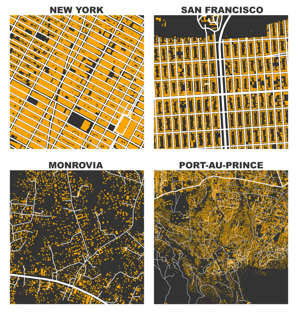
I previously demonstrated how to create figure-ground square-mile visualizations of urban street networks with OSMnx to consistently compare city patterns, design paradigms, and connectivity. OSMnx downloads, analyzes, and visualizes street networks from OpenStreetMap but it can also get building footprints. If we mash-up these building footprints with the street networks, we get a fascinating comparative window into urban form:

Figure-ground map of building footprints and street network in New York, San Francisco, Monrovia, and Port au Prince from OpenStreetMap data, created in Python with OSMnx

Categories
Tech

Getting Started with Python

Piedmont, California street network created in Python with OSMnx, networkx, matplotlibThis is a guide for absolute beginners to get started using Python. Since releasing OSMnx a few weeks ago, I’ve received a lot of comments from people who would love to try it out, but don’t know where to begin with Python. I’ll demonstrate how to get Python up and running on your system, how to install packages, and how to run code.