Categories
Urban

Scaling Urban Indicators

I have a new article out now in the journal of Urban Policy and Research coauthored with a team comprising many of the folks from our recent series in The Lancet Global Health. The article is titled “Policy-Relevant Spatial Indicators of Urban Liveability and Sustainability: Scaling from Local to Global” and discusses measuring urban indicators and scaling the software to calculate them from a local case study to a worldwide effort.

From the abstract:

Urban liveability is a global priority for creating healthy, sustainable cities. Measurement of policy-relevant spatial indicators of the built and natural environment supports city planning at all levels of government. Analysis of their spatial distribution within cities, and impacts on individuals and communities, is crucial to ensure planning decisions are effective and equitable. This paper outlines challenges and lessons from a 5-year collaborative research program, scaling up a software workflow for calculating a composite indicator of urban liveability for residential address points across Melbourne, to Australia’s 21 largest cities, and further extension to 25 global cities in diverse contexts.

For more, check out the article itself. And you may also be interested in our recent The Lancet Global Health series of articles that developed similar themes in great depth.

Categories
Planning

Two-Way Streets and Network Efficiency

I have a new article out now in the Journal of Planning Education and Research with Billy Riggs, in which we examine how two-way street conversions impact street network efficiency. Most of the efficiency literature looks at the benefits of one-way streets for signalization and vehicular throughput. We took a different approach, considering how one-way streets inherently increase travel distances.

Categories
Urban

The Lancet Global Health Series on Urban Design, Transport, and Health

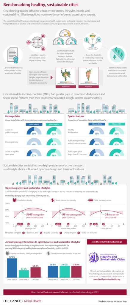
After many years of hard work, our series of articles on urban design, transport, and health has been published by The Lancet Global Health.

The Lancet Global Health infographic on benchmarking healthy sustainable citiesIn our first paper, we analyzed urban policies and calculated built environment indicators for 25 cities across 6 continents to assess walkability and accessibility. Our policy analysis found policies inconsistent with public health evidence, rhetoric endorsing health and sustainability but few measurable policy targets, and substantial implementation gaps.

Categories
Planning

Framework for Measuring Pedestrian Accessibility

I’m a co-author of a new article, “A Generalized Framework for Measuring Pedestrian Accessibility around the World Using Open Data,” which has just been published by Geographical Analysis. We developed an open source, containerized software framework for modeling pedestrian networks using open data to analyze disaggregate access to daily living needs. We worked with local partners in 25 cities around the world to demonstrate and validate this toolkit.

From the abstract:

Pedestrian accessibility is an important factor in urban transport and land use policy and critical for creating healthy, sustainable cities. Developing and evaluating indicators measuring inequalities in pedestrian accessibility can help planners and policymakers benchmark and monitor the progress of city planning interventions. However, measuring and assessing indicators of urban design and transport features at high resolution worldwide to enable city comparisons is challenging due to limited availability of official, high quality, and comparable spatial data, as well as spatial analysis tools offering customizable frameworks for indicator construction and analysis. To address these challenges, this study develops an open source software framework to construct pedestrian accessibility indicators for cities using open and consistent data. It presents a generalized method to consistently measure pedestrian accessibility at high resolution and spatially aggregated scale, to allow for both within- and between-city analyses. The open source and open data methods developed in this study can be extended to other cities worldwide to support local planning and policymaking. The software is made publicly available for reuse in an open repository.

For more, check out the article.

Categories
Urban

Urban Form and OpenStreetMap

My chapter “Exploring Urban Form Through OpenStreetMap Data: A Visual Introduction” has just been published in the new book Urban Experience and Design: Contemporary Perspectives on Improving the Public Realm edited by Justin Hollander and Ann Sussman.

From the abstract:

This chapter introduces OpenStreetMap—a crowdsourced, worldwide mapping project and geospatial data repository—to illustrate its usefulness in quickly and easily analyzing and visualizing planning and design outcomes in the built environment. It demonstrates the OSMnx toolkit for automatically downloading, modeling and visualizing spatial data from OpenStreetMap. We explore patterns and configurations in street networks and buildings around the world computationally through visualization methods—including figure-ground diagrams and polar histograms—that help compress urban complexity into comprehensible artifacts that reflect the human experience of the built environment. Ubiquitous urban data and computation can open up new urban form analyses from both quantitative and qualitative perspectives.

For more, check out the chapter.

Categories
Planning

Off the Grid at TRB

I am presenting my ongoing research into the recent evolution of American street network planning and design at the annual meeting of the Transportation Research Board in Washington DC on January 13. This presentation asks the question: how has street network design changed over time, especially in recent years? I analyze the street networks of every US census tract and estimate each’s vintage.

Street network designs grew more disconnected, coarse-grained, and circuitous over the 20th century… but the 21st century has witnessed a promising rebound back toward more traditional, dense, and interconnected grids. Higher griddedness is associated with less car ownership, even when controlling for related socioeconomic, topographical, and other urban factors.

Update: the paper has been published in JAPA.

Categories
Planning

New Chapter: Street Network Morphology

My chapter The Morphology and Circuity of Walkable and Drivable Street Networks is now in-press for publication in the forthcoming book The Mathematics of Urban Morphology (download free PDF). The book integrates recent theoretical and empirical work from urban planning, geography, sociology, architecture, economics, and mathematics around the theme of how we model and understand the urban form’s physical patterns and shaping processes. Fellow authors in this volume include Michael Batty, Diane Davis, Keith Clarke, Bin Jiang, Kay Axhausen, Carlo Ratti, and Stephen Marshall. The book itself can be purchased here.

Categories
Planning

New Article: Planar Models of Street Networks

My article, “Planarity and Street Network Representation in Urban Form Analysis,” was recently published in Environment and Planning B: Urban Analytics and City Science. Models of street networks underlie research in urban travel behavior, accessibility, design patterns, and morphology. These models are commonly defined as planar, meaning they can be represented in two dimensions without any underpasses or overpasses. However, real-world urban street networks exist in three-dimensional space and frequently feature grade separation such as bridges and tunnels: planar simplifications can be useful but they also impact the results of real-world street network analysis. This study measures the nonplanarity of drivable and walkable street networks in the centers of 50 cities worldwide, then examines the variation of nonplanarity across a single city. While some street networks are approximately planar, I empirically quantify how planar models can inconsistently but drastically misrepresent intersection density, street lengths, routing, and connectivity.

Categories
Urban

New Article: Complexity in Urban Form and Design

My article, Measuring the Complexity of Urban Form and Design, is now in-press for publication at Urban Design International (download free PDF). Cities are complex systems composed of many human agents interacting in physical urban space. This paper develops a typology of measures and indicators for assessing the physical complexity of the built environment at the scale of urban design. It extends quantitative measures from city planning, network science, ecosystems studies, fractal geometry, statistical physics, and information theory to the analysis of urban form and qualitative human experience.

The Mandelbrot set, a mathematical fractal. Venice's fractal urban form and fabric. The Eiffel Tower's fractal architecture in Paris.

Categories
Planning

City Street Orientations around the World

City street network grid orientations, order, disorder, entropy, rose plot, polar histogram made with Python, OSMnx, OpenStreetMap, matplotlib.This post is adapted from this research paper that you can read/cite for more info. It analyzes and visualizes 100 cities around the world.

By popular request, this is a quick follow-up to this post comparing the orientation of streets in 25 US cities using Python and OSMnx. Here are 25 more cities around the world:

City street network grid orientations, rose plot, polar histogram made with Python, OSMnx, OpenStreetMap, matplotlib. Bangkok, Barcelona, Beijing, Budapest, Cairo, Delhi, Dubai, Glasgow, Hong Kong, Lagos, London, Madrid, Melbourne, Mexico City, Moscow, Mumbai, Munich, Paris, Rio de Janeiro, Rome, Seoul, Sydney, Tehran, Toronto, Warsaw, Tokyo, Berlin, Venice