Categories
Uncategorized

A Roadmap for Data-Driven Urban Research

I recently coauthored an article in the journal Cities titled “A Road Map for Future Data-Driven Urban Planning and Environmental Health Research.” This arose from a symposium in Sitges, Spain which I was invited to last year by the Barcelona Institute for Global Health.

From the abstract:

Recent advances in data science and urban environmental health research utilise large-scale databases (100s–1000s of cities) to explore the complex interplay of urban characteristics such as city form and size, climate, mobility, exposure, and environmental health impacts. Cities are still hotspots of air pollution and noise, suffer urban heat island effects and lack of green space, which leads to disease and mortality burdens preventable with better knowledge. Better understanding through harmonising and analysing data in large numbers of cities is essential to identifying the most effective means of disease prevention and understanding context dependencies important for policy.

For more, check out the article.

Categories
Academia

Urban Form, Transport, Environment and Health

I recently coauthored an article in Environmental Research, titled “Exploring the Nexus of Urban Form, Transport, Environment and Health in Large-Scale Urban Studies: A State-of-the-Art Scoping Review.” This arose from a symposium in Sitges, Spain which I was invited to last year by the Barcelona Institute for Global Health.

From the abstract:

As the world becomes increasingly urbanised, there is recognition that public and planetary health relies upon a ubiquitous transition to sustainable cities. Disentanglement of the complex pathways of urban design, environmental exposures, and health, and the magnitude of these associations, remains a challenge. A state-of-the-art account of large-scale urban health studies is required to shape future research priorities and equity- and evidence-informed policies. The purpose of this review was to synthesise evidence from large-scale urban studies focused on the interaction between urban form, transport, environmental exposures, and health. This review sought to determine common methodologies applied, limitations, and future opportunities for improved research practice. Based on a literature search, 2958 articles were reviewed that covered three themes of: urban form; urban environmental health; and urban indicators. Studies were prioritised for inclusion that analysed at least 90 cities to ensure broad geographic representation and generalisability. Of the initially identified studies, following expert consultation and exclusion criteria, 66 were included. The complexity of the urban ecosystem on health was evidenced from the context dependent effects of urban form variables on environmental exposures and health. Compact city designs were generally advantageous for reducing harmful environmental exposure and promoting health, with some exceptions. Methodological heterogeneity was indicative of key urban research challenges; notable limitations included exposure and health data at varied spatial scales and resolutions, limited availability of local-level sociodemographic data, and the lack of consensus on robust methodologies that encompass best research practice. Future urban environmental health research for evidence-informed urban planning and policies requires a multi-faceted approach. Advances in geospatial and AI-driven techniques and urban indicators offer promising developments; however, there remains a wider call for increased data availability at local-levels, transparent and robust methodologies of large-scale urban studies, and greater exploration of urban health vulnerabilities and inequities.

For more, check out the article.
Categories
Planning

Delivering Healthy and Sustainable Cities

I have a new article out now in The Journal of City Climate Policy and Economy, coauthored with a team that includes several of the folks from our recent series in The Lancet Global Health. The JCCPE article, “A Pathway to Prioritizing and Delivering Healthy and Sustainable Cities,” synthesizes findings and recommended policy actions arising from that recent TLGH series.

From the abstract:

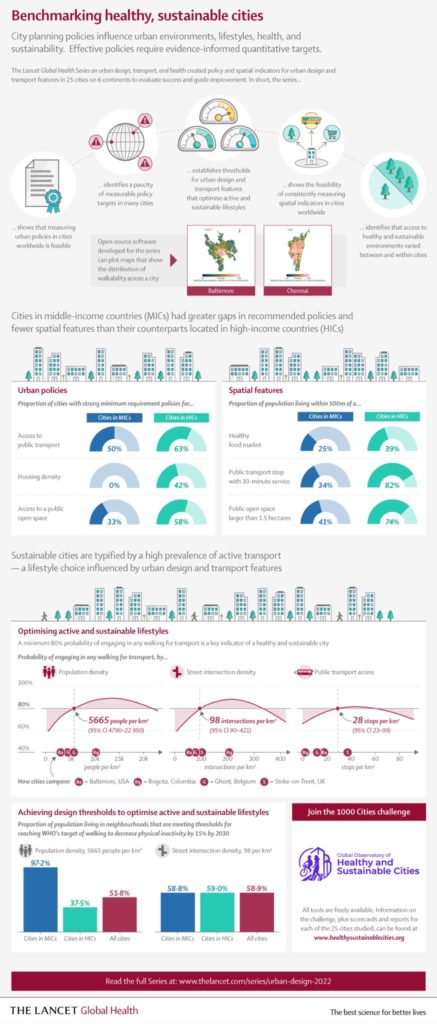
Creating healthy and sustainable cities should be a global priority. Some cities prioritize 15-minute cities as a planning approach with co-benefits for health, climate change mitigation, equity, and economic recovery from COVID-19. Yet, as our recent The Lancet Global Health series on “Urban Design, Transport, and Health” showed, many cities have a long way to go to achieve this vision. This policy guideline summarizes the main findings of the series, which assessed health and sustainability indicators for 25 cities in 19 countries. We then outline steps governments can take to strengthen policy frameworks and deliver more healthy, equitable, and sustainable built environments. The Lancet Global Health series provided clear evidence that cities need to transform urban governance to enable integrated planning for health and sustainability and commit to policy implementation. Evidence-informed indicators should be used to benchmark and monitor progress. Cities need policy frameworks that are comprehensive and consistent with evidence, with measurable policy targets to support implementation and accountability. The series provided evidence-informed thresholds for some key urban design and transport features, which can be embedded as policy targets. Policies and interventions must prioritize identifying and reducing inequities in access to health-supportive environments. Governments should also invest in open data and promote citizen-science programmes, to support indicator development and research for public benefit. We provide tools to replicate our indicators and an invitation to join our 1,000 Cities Challenge via the Global Observatory of Healthy and Sustainable Cities.

For more, check out the JCCPE article itself. And you may also be interested in our recent The Lancet Global Health series of articles that developed similar themes in great depth.

Categories
Planning

ISPAH in Abu Dhabi

Alongside Billie Giles-Corti and Jim Sallis, I will be presenting our team’s recent research into accessible, sustainable urban design around the world at the ISPAH Congress in Abu Dhabi this week. Our symposium at the congress will share the methods and findings from our The Lancet Global Health series published this summer, as well as our ongoing work on the Thousand Cities Challenge.

Our geospatial team developed open-source software to calculate indicators of walkability and accessibility around the world, and then linked these back to cities’ policy contexts and identified populations living above and below estimated thresholds for physical activity. Few cities had measurable policy standards and targets to actually build healthier and more sustainable cities, and their health-supportive built environment features were often inadequate or inequitably distributed.

We simultaneously launched the Global Observatory of Healthy and Sustainable Cities to promote healthy and sustainable urban planning, benchmark and monitor cities’ progress, and share more consistent, comparable urban data. The whole series of articles is free and open access, as is our software.

Categories
Urban

The Lancet Global Health Series on Urban Design, Transport, and Health

After many years of hard work, our series of articles on urban design, transport, and health has been published by The Lancet Global Health.

The Lancet Global Health infographic on benchmarking healthy sustainable citiesIn our first paper, we analyzed urban policies and calculated built environment indicators for 25 cities across 6 continents to assess walkability and accessibility. Our policy analysis found policies inconsistent with public health evidence, rhetoric endorsing health and sustainability but few measurable policy targets, and substantial implementation gaps.

Categories
Planning

Framework for Measuring Pedestrian Accessibility

I’m a co-author of a new article, “A Generalized Framework for Measuring Pedestrian Accessibility around the World Using Open Data,” which has just been published by Geographical Analysis. We developed an open source, containerized software framework for modeling pedestrian networks using open data to analyze disaggregate access to daily living needs. We worked with local partners in 25 cities around the world to demonstrate and validate this toolkit.

From the abstract:

Pedestrian accessibility is an important factor in urban transport and land use policy and critical for creating healthy, sustainable cities. Developing and evaluating indicators measuring inequalities in pedestrian accessibility can help planners and policymakers benchmark and monitor the progress of city planning interventions. However, measuring and assessing indicators of urban design and transport features at high resolution worldwide to enable city comparisons is challenging due to limited availability of official, high quality, and comparable spatial data, as well as spatial analysis tools offering customizable frameworks for indicator construction and analysis. To address these challenges, this study develops an open source software framework to construct pedestrian accessibility indicators for cities using open and consistent data. It presents a generalized method to consistently measure pedestrian accessibility at high resolution and spatially aggregated scale, to allow for both within- and between-city analyses. The open source and open data methods developed in this study can be extended to other cities worldwide to support local planning and policymaking. The software is made publicly available for reuse in an open repository.

For more, check out the article.