Categories
Tech

Global Healthy and Sustainable City Indicators

I recently co-authored an article, “Global Healthy and Sustainable City Indicators: Collaborative Development of an Open Science Toolkit for Calculating and Reporting on Urban Indicators Internationally,” now published in Environment and Planning B: Urban Analytics and City Science. This was a collaboration with my colleagues at the Global Observatory of Healthy and Sustainable Cities, in which we discuss our spatial software co-development process with collaborators and practitioners around the world.

From the abstract:

Measuring and monitoring progress towards achieving healthy, equitable and sustainable cities is a priority for planners, policymakers and researchers in diverse contexts globally. Yet data collection, analysis, visualisation and reporting on policy and spatial indicators involve specialised knowledge, skills, and collaboration across disciplines. Integrated open-source tools for calculating and communicating urban indicators for diverse urban contexts are needed, which provide the multiple streams of evidence required to influence policy agendas and enable local changes towards healthier and more sustainable cities. This paper reports on the development of open-source software for planning, analysis and generation of data, maps and reports on policy and spatial indicators of urban design and transport features for healthy and sustainable cities. We engaged a collaborative network of researchers and practitioners from diverse geographic contexts through an online survey and workshops, to understand and progressively meet their requirements for policy and spatial indicators. We outline our framework for action research-informed open-source software development and discuss benefits and challenges of this approach. The resulting Global Healthy and Sustainable City Indicators software is designed to meet the needs of researchers, planners, policy makers and community advocates in diverse settings for planning, calculating and disseminating policy and spatial urban indicators.

For more, check out the article.

Categories
Academia

Surfacic Networks

I recently coauthored an article titled “Surfacic Networks” in PNAS Nexus with Marc Barthelemy, Alain Chiaradia, and Chris Webster. We propose the concept of surfacic networks to describe a class of spatial networks embedded in non-flat two-dimensional manifolds (e.g., the Earth’s surface), and what this means for distance metrics and lazy path solving when accounting for fluctuations in the manifold’s curvature (e.g., changes in elevation on Earth’s surface).

Surfacic network: a spatial network embedded in a non-flat two-dimensional manifold such as the Earth's surface accounting for elevation changesFrom the abstract:

Surfacic networks are structures built upon a 2D manifold. Many systems, including transportation networks and various urban networks, fall into this category. The fluctuations of node elevations imply significant deviations from typical plane networks and require specific tools to understand their impact. Here, we present such tools, including lazy paths that minimize elevation differences, graph arduousness which measures the tiring nature of shortest paths (SPs), and the excess effort, which characterizes positive elevation variations along SPs. We illustrate these measures using toy models of surfacic networks and empirically examine pedestrian networks in selected cities. Specifically, we examine how changes in elevation affect the spatial distribution of betweenness centrality. We also demonstrate that the excess effort follows a nontrivial power law distribution, with an exponent that is not universal, which illustrates that there is a significant probability of encountering steep slopes along SPs, regardless of the elevation difference between the starting point and the destination. These findings highlight the significance of elevation fluctuations in shaping network characteristics. Surfacic networks offer a promising framework for comprehensively analyzing and modeling complex systems that are situated on or constrained to a surface environment.

For more, check out the article.

Categories
Data

OSMnx 2.0 Released

OSMnx version 2.0.0 has been released. This has been a massive effort over the past year to streamline the package’s API, re-think its internal organization, and optimize its code. Today OSMnx is faster, more memory efficient, and fully type-annotated for a better user experience.

If you haven’t used it before, OSMnx is a Python package to easily download, model, analyze, and visualize street networks and any other geospatial features from OpenStreetMap. You can download and model walking, driving, or biking networks with a single line of code then quickly analyze and visualize them. You can just as easily work with urban amenities/points of interest, building footprints, transit stops, elevation data, street orientations, speed/travel time, and routing.OSMnx: Figure-ground diagrams of one square mile of each street network, from OpenStreetMap, made in Python with matplotlib, geopandas, and NetworkX
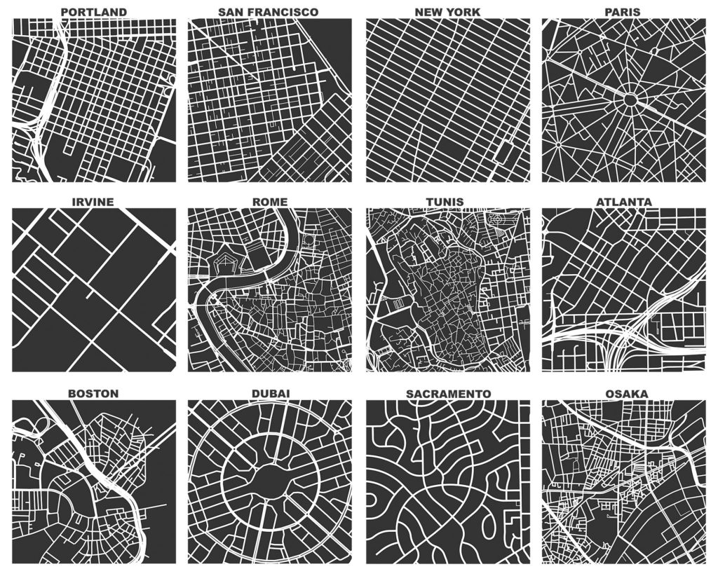
This has now been a labor of love for me for about 9 years. Wow. I initially developed this package to enable the empirical research for my dissertation. Since then, it has powered probably 2/3 of the articles I’ve published over the years. And it has received hundreds of contributions from many other code contributors. Thank you to everyone who helped make this possible.

I hope you find the package as useful as I do. Now I’m looking forward to all of your bug reports.

Categories
Planning

Resilient by Design

I have a new article out now in Transportation Research Part A: Policy and Practice. Here’s a free open-access preprint if you lack institutional access.

We simulate over 2.4 billion trips across every urban area in the world to measure street network vulnerability to disasters, then measure the relationships between street network design and these vulnerability indicators.

First we modeled the street networks of more than 8,000 urban areas in 178 countries. Then, for each urban area, we simulated disasters of 3 different types (representing floods, earthquakes, and targeted attacks) and 10 different extents. Then we simulated over 2.4 billion trips on these networks to measure how certain trips become more circuitous or even impossible to complete as parts of the network fail after a disaster. Finally we built a model to predict how much a disaster would impact trips.

Categories
Planning

Street Network Design and GHG Emissions

I have a new article out in Transportation Research Part D that estimates relationships between street network characteristics and transport CO2 emissions across every urban area in the world and investigates whether they are the same across development levels and design paradigms.

The relationships between street network design and transport emissions in the US, Europe, and China are well-studied. But not so in many of the most rapidly developing parts of the world. Practitioners lack a strong local evidence base for local evidence-informed planning.

Categories
Urban

Equity in the Built Environment

I coauthored a recently published article in Building and Environment which systematically reviews perspectives on and approaches to social equity in the built environment. From the abstract:

Equity in the built environment refers to the extent to which the built environment meets the needs of different groups through planning, design, construction, operation, management, and regulation. Though much studied in recent years, some needs and groups have received a greater research focus than others, and significant inequities continue to exist. Following PRISMA guidelines, we systematically reviewed the distributional and recognitional aspects of inequities experienced by vulnerable groups regarding their needs while using/occupying different types of built environments. We find that more studies focus on inequities regarding residential buildings, transportation facilities, and public open spaces, whereas comparatively few studies examine water and energy infrastructure, commercial buildings, educational buildings, and healthcare facilities. More studies focus on well-being, mobility, and access needs than shelter and safety needs. Inequities experienced by minorities, people with low socioeconomic status, people with health concerns, and vulnerable age groups receive more attention than the inequities experienced by people with gender/sexual-orientation vulnerability or displaced groups. The literature exhibits a relatively narrow focus on some subgroups, such as refugees, people experiencing homelessness, people with cognitive differences, people with visual or hearing impairments, children, and women. We argue that these findings demarcate high-impact future research directions to address vulnerable groups’ needs worldwide and suggest measures to alleviate inequities in the built environment.

For more, check out the article itself in Building and Environment.

Categories
Planning

Rethinking the One-Way Street

I recently published an article in Transfers Magazine with Billy Riggs questioning some of the received wisdom about one-way streets and efficiency. This builds on our recent research published in JPER modeling vehicle distance traveled before and after hypothetical one-way to two-way street conversions.

Categories
Planning

Delivering Healthy and Sustainable Cities

I have a new article out now in The Journal of City Climate Policy and Economy, coauthored with a team that includes several of the folks from our recent series in The Lancet Global Health. The JCCPE article, “A Pathway to Prioritizing and Delivering Healthy and Sustainable Cities,” synthesizes findings and recommended policy actions arising from that recent TLGH series.

From the abstract:

Creating healthy and sustainable cities should be a global priority. Some cities prioritize 15-minute cities as a planning approach with co-benefits for health, climate change mitigation, equity, and economic recovery from COVID-19. Yet, as our recent The Lancet Global Health series on “Urban Design, Transport, and Health” showed, many cities have a long way to go to achieve this vision. This policy guideline summarizes the main findings of the series, which assessed health and sustainability indicators for 25 cities in 19 countries. We then outline steps governments can take to strengthen policy frameworks and deliver more healthy, equitable, and sustainable built environments. The Lancet Global Health series provided clear evidence that cities need to transform urban governance to enable integrated planning for health and sustainability and commit to policy implementation. Evidence-informed indicators should be used to benchmark and monitor progress. Cities need policy frameworks that are comprehensive and consistent with evidence, with measurable policy targets to support implementation and accountability. The series provided evidence-informed thresholds for some key urban design and transport features, which can be embedded as policy targets. Policies and interventions must prioritize identifying and reducing inequities in access to health-supportive environments. Governments should also invest in open data and promote citizen-science programmes, to support indicator development and research for public benefit. We provide tools to replicate our indicators and an invitation to join our 1,000 Cities Challenge via the Global Observatory of Healthy and Sustainable Cities.

For more, check out the JCCPE article itself. And you may also be interested in our recent The Lancet Global Health series of articles that developed similar themes in great depth.

Categories
Planning

ISPAH in Abu Dhabi

Alongside Billie Giles-Corti and Jim Sallis, I will be presenting our team’s recent research into accessible, sustainable urban design around the world at the ISPAH Congress in Abu Dhabi this week. Our symposium at the congress will share the methods and findings from our The Lancet Global Health series published this summer, as well as our ongoing work on the Thousand Cities Challenge.

Our geospatial team developed open-source software to calculate indicators of walkability and accessibility around the world, and then linked these back to cities’ policy contexts and identified populations living above and below estimated thresholds for physical activity. Few cities had measurable policy standards and targets to actually build healthier and more sustainable cities, and their health-supportive built environment features were often inadequate or inequitably distributed.

We simultaneously launched the Global Observatory of Healthy and Sustainable Cities to promote healthy and sustainable urban planning, benchmark and monitor cities’ progress, and share more consistent, comparable urban data. The whole series of articles is free and open access, as is our software.

Categories
Planning

Two-Way Streets and Network Efficiency

I have a new article out now in the Journal of Planning Education and Research with Billy Riggs, in which we examine how two-way street conversions impact street network efficiency. Most of the efficiency literature looks at the benefits of one-way streets for signalization and vehicular throughput. We took a different approach, considering how one-way streets inherently increase travel distances.