Categories
Urban

Equity in the Built Environment

I coauthored a recently published article in Building and Environment which systematically reviews perspectives on and approaches to social equity in the built environment. From the abstract:

Equity in the built environment refers to the extent to which the built environment meets the needs of different groups through planning, design, construction, operation, management, and regulation. Though much studied in recent years, some needs and groups have received a greater research focus than others, and significant inequities continue to exist. Following PRISMA guidelines, we systematically reviewed the distributional and recognitional aspects of inequities experienced by vulnerable groups regarding their needs while using/occupying different types of built environments. We find that more studies focus on inequities regarding residential buildings, transportation facilities, and public open spaces, whereas comparatively few studies examine water and energy infrastructure, commercial buildings, educational buildings, and healthcare facilities. More studies focus on well-being, mobility, and access needs than shelter and safety needs. Inequities experienced by minorities, people with low socioeconomic status, people with health concerns, and vulnerable age groups receive more attention than the inequities experienced by people with gender/sexual-orientation vulnerability or displaced groups. The literature exhibits a relatively narrow focus on some subgroups, such as refugees, people experiencing homelessness, people with cognitive differences, people with visual or hearing impairments, children, and women. We argue that these findings demarcate high-impact future research directions to address vulnerable groups’ needs worldwide and suggest measures to alleviate inequities in the built environment.

For more, check out the article itself in Building and Environment.

Categories
Urban

Scaling Urban Indicators

I have a new article out now in the journal of Urban Policy and Research coauthored with a team comprising many of the folks from our recent series in The Lancet Global Health. The article is titled “Policy-Relevant Spatial Indicators of Urban Liveability and Sustainability: Scaling from Local to Global” and discusses measuring urban indicators and scaling the software to calculate them from a local case study to a worldwide effort.

From the abstract:

Urban liveability is a global priority for creating healthy, sustainable cities. Measurement of policy-relevant spatial indicators of the built and natural environment supports city planning at all levels of government. Analysis of their spatial distribution within cities, and impacts on individuals and communities, is crucial to ensure planning decisions are effective and equitable. This paper outlines challenges and lessons from a 5-year collaborative research program, scaling up a software workflow for calculating a composite indicator of urban liveability for residential address points across Melbourne, to Australia’s 21 largest cities, and further extension to 25 global cities in diverse contexts.

For more, check out the article itself. And you may also be interested in our recent The Lancet Global Health series of articles that developed similar themes in great depth.

Categories
Urban

The Lancet Global Health Series on Urban Design, Transport, and Health

After many years of hard work, our series of articles on urban design, transport, and health has been published by The Lancet Global Health.

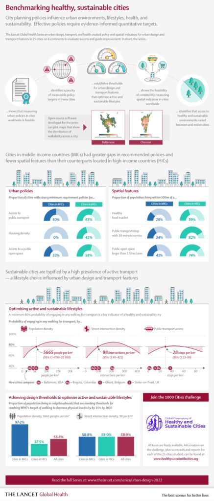
The Lancet Global Health infographic on benchmarking healthy sustainable citiesIn our first paper, we analyzed urban policies and calculated built environment indicators for 25 cities across 6 continents to assess walkability and accessibility. Our policy analysis found policies inconsistent with public health evidence, rhetoric endorsing health and sustainability but few measurable policy targets, and substantial implementation gaps.

Categories
Urban

Housing Tech and Tilted Platforms

I have a new article out now in a special issue on platform urbanism, co-authored with Max Besbris, David Wachsmuth, and Jake Wegmann, titled Tilted Platforms: Rental Housing Technology and the Rise of Urban Big Data Oligopolies. We reflect on short-term and long-term rental housing technologies and how they’re affecting the housing search, equity, and affordability.

From the abstract:

This article interprets emerging scholarship on rental housing platforms—particularly the most well-known and used short- and long-term rental housing platforms—and considers how the technological processes connecting both short-term and long-term rentals to the platform economy are transforming cities. It discusses potential policy approaches to more equitably distribute benefits and mitigate harms. We argue that information technology is not value-neutral. While rental housing platforms may empower data analysts and certain market participants, the same cannot be said for all users or society at large. First, user-generated online data frequently reproduce the systematic biases found in traditional sources of housing information. Evidence is growing that the information broadcasting potential of rental housing platforms may increase rather than mitigate sociospatial inequality. Second, technology platforms curate and shape information according to their creators’ own financial and political interests. The question of which data—and people—are hidden or marginalized on these platforms is just as important as the question of which data are available. Finally, important differences in benefits and drawbacks exist between short-term and long-term rental housing platforms, but are underexplored in the literature: this article unpacks these differences and proposes policy recommendations.

For more, check out the article.

Categories
Urban

Urban Form and OpenStreetMap

My chapter “Exploring Urban Form Through OpenStreetMap Data: A Visual Introduction” has just been published in the new book Urban Experience and Design: Contemporary Perspectives on Improving the Public Realm edited by Justin Hollander and Ann Sussman.

From the abstract:

This chapter introduces OpenStreetMap—a crowdsourced, worldwide mapping project and geospatial data repository—to illustrate its usefulness in quickly and easily analyzing and visualizing planning and design outcomes in the built environment. It demonstrates the OSMnx toolkit for automatically downloading, modeling and visualizing spatial data from OpenStreetMap. We explore patterns and configurations in street networks and buildings around the world computationally through visualization methods—including figure-ground diagrams and polar histograms—that help compress urban complexity into comprehensible artifacts that reflect the human experience of the built environment. Ubiquitous urban data and computation can open up new urban form analyses from both quantitative and qualitative perspectives.

For more, check out the chapter.

Categories
Urban

Housing Search in the Age of Big Data

My article “Housing Search in the Age of Big Data: Smarter Cities or the Same Old Blind Spots?” with Max Besbris, Ariela Schachter, and John Kuk is now published in Housing Policy Debate. We look at the quantity and quality of information in online housing listings and find that they are much higher in White and non-poor neighborhoods than they are in poor, Black, or Latino neighborhoods. Listings in White neighborhoods include more descriptive text and focus on unit and neighborhood amenities, while listings in Black neighborhoods focus more on applicant (dis)qualifications. We discuss what this means for housing markets, filter bubbles, residential sorting and segregation, and housing policy. You can download a free PDF.

Housing search technologies are changing and, as a result, so are housing search behaviors. The most recent American Housing Survey revealed that, for the first time, more urban renters found their current homes through online technology platforms than any other information channel. These technology platforms collect and disseminate user-generated content and construct a virtual agora for users to share information with one another. Because they can provide real-time data about various urban phenomena, housing technology platforms are a key component of the smart cities paradigm.

This paradigm promotes information technology as both a technocratic mode of monitoring cities and a utopian mode of improving urban life through big data. In this context, “big data” typically refers to massive streams of user-generated content resulting from millions or billions of decentralized human actions. Data exhaust from Craigslist and other housing technology platforms offers a good example: optimistically, large corpora of rental listings could provide housing researchers and practitioners with actionable insights for policymaking while also equalizing access to information for otherwise disadvantaged homeseekers. But how good are these platforms at resolving the types of problems that already plague old-fashioned, non-big data? Does this broadcasting of information reduce longstanding geographic and demographic inequalities or do established patterns of segmentation and sorting remain?

Categories
Urban

Big Data in Urban Morphology

My new article “Spatial Information and the Legibility of Urban Form: Big Data in Urban Morphology” has been published in the International Journal of Information Management (download free PDF). It builds on recent work by Crooks et al, presenting workflows to integrate data-driven and narrative approaches to urban morphology in today’s era of ubiquitous urban big data. It situates this theoretically in the visual culture of planning to present a visualization-mediated interpretative process of data-driven urban morphology, focusing on transportation infrastructure via OSMnx.

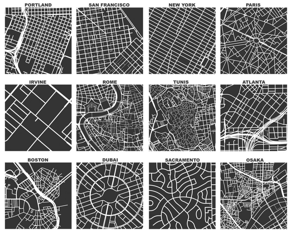
OSMnx: Figure-ground diagrams of one square mile of each street network, from OpenStreetMap, made in Python with matplotlib, geopandas, and NetworkX

Categories
Urban

Urban Street Network Orientation

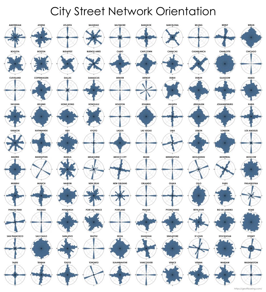
My new article, Urban Spatial Order: Street Network Orientation, Configuration, and Entropy, has just been published in one of my favorite journals: Applied Network Science (download free PDF). This study explores the spatial signatures of urban evolution and central planning. It examines street network orientation, connectivity, granularity, and entropy in 100 cities around the world using OpenStreetMap data and OSMnx for modeling and visualization:

City street network grid orientations, order, disorder, entropy, rose plot, polar histogram made with Python, OSMnx, OpenStreetMap, matplotlib.

So, who’s got a grid and who doesn’t? Each of the cities above is represented by a polar histogram (aka rose diagram) depicting how its streets orient. Each bar’s direction represents the compass bearings of the streets (in that histogram bin) and its length represents the relative frequency of streets with those bearings. The cities above are in alphabetical order. Here they are again, re-sorted from most-ordered/gridded city (Chicago) to most-disordered (Charlotte):

Categories
Urban

New Article: Complexity in Urban Form and Design

My article, Measuring the Complexity of Urban Form and Design, is now in-press for publication at Urban Design International (download free PDF). Cities are complex systems composed of many human agents interacting in physical urban space. This paper develops a typology of measures and indicators for assessing the physical complexity of the built environment at the scale of urban design. It extends quantitative measures from city planning, network science, ecosystems studies, fractal geometry, statistical physics, and information theory to the analysis of urban form and qualitative human experience.

The Mandelbrot set, a mathematical fractal. Venice's fractal urban form and fabric. The Eiffel Tower's fractal architecture in Paris.

Categories
Urban

Aftermath of the Berkeley Protests

I walked around downtown Berkeley this morning and took photos of the aftermath of last night’s protests. It had been a predominately peaceful event. Out of 500+ protesters, only 4-5 individuals smashed windows, started fires, and looted local businesses. The ransackers sadly had nothing to do with the message of the protest. Rather, these were opportunists who camouflaged themselves among peaceful protesters to loot and vandalize under the cloak of anonymity granted by a large group.

It was a frustrating distraction away from the protest’s message, and it undermined the peaceful majority. Now the national news is focused on the destruction caused by a small group, instead of discussing the point of the protest. Do not conflate the protesters with the vandals – these were two separate groups out last night for different reasons.